CONVECTIVE FORECAST
VALID Mon 22 Aug 06:00 - Tue 23 Aug 06:00 2005 (UTC)
ISSUED: 22 Aug 07:19 (UTC)
FORECASTER: GROENEMEIJER
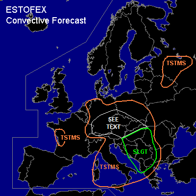
There is a slight risk of severe thunderstorms forecast across southern Hungary, eastern Croatia, Bosnia and Herzegovina, Serbia and Montenegro, western Romania, Alabina, a part of the F.Y.R. of Macedonia and extreme western Bulgaria.
SYNOPSIS
Monday at 06 UTC... a mid/upper area of low pressure was located over northern Italy. this system is expected to move slightly eastward during the forecast period. A cyclonically-curved jet located on its southern flank is expected to mvoe into the central Balkans.
DISCUSSION
...Balkans...
Within the left exit region of the jet, upward motion and steepening low-level lapse rates are expected to occur over eastern Croatia, Serbia and Montenegro, and much of Hungary as well as western Romania. GFS indicates that more than 1500 J/kg of SBCAPE may form in response to solar heating. This does not seem to be excessive given the rather modest surface dew points in the model. Moderate (around 15 m/s) deep-layer shear is expected over western Hungary and Croatia. Further east and south, deep-layer shear is expected to be stronger (up to around 30 m/s). Well-organized storms are expected to form there during the afternoon, likely including supercells, whereas further west clusters of multicells will be the dominant convective mode. Across the entire slight risk area, storms may produce damaging winds and large hail. Across eastern Hungary, Serbia and western Romania, a threat of tornadoes will exist as well as somewhat higher levels of low-level shear and helicity should be favourable for their formation. The area will be monitored for an upgrade to moderate risk.
Along the western Balkan coast, storms are presently ongoing and this is expected to continue during the day. In associating with these storms large hail, damaging winds are possible, as well as an isolated tornado.
...Central Europe...
Within the area marked 'see text' scattered thunderstorms are expected to form as well as moderate CAPE values, weak capping and forcing for upward motions coincide. Small Corfidi vectors suggest that multicell clusters will have very small velocities as propagation towards the (south-)east offsets cell-advection towards the (north-)west. As a result high precipitation accumulations are to be expected.
#