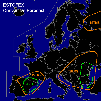

CONVECTIVE FORECAST
VALID Wed 17 Aug 06:00 - Thu 18 Aug 06:00 2005 (UTC)
ISSUED: 16 Aug 23:51 (UTC)
FORECASTER: GATZEN
There is a slight risk of severe thunderstorms forecast across western Black Sea
There is a slight risk of severe thunderstorms forecast across eastern and northern Iberian Peninsula
SYNOPSIS
Intense upper cut-off low present over western Balkans slowly moves SE-ward. At its eastern flank ... warm and unstable airmass remains over Black Sea region, while stable airmass spreads into central and eastern Mediterranean. To the west ... weak upper trough will be quasistationary over Bay of Biscay ... providing a SW-erly upper flow over Iberian Peninsula, and western Mediterranean. Over northern Europe ... intense polar trough moves eastward over Scandinavia. Another intense trough follows from northern Atlantic ocean ... reaching British Isles at the end of the period. Over central Europe ... weak high will remain.
DISCUSSION
...Black Sea region
...
Latest soundings show rich low-level moisture over Black Sea region ... reaching 14 g/kg mixing ratio at Istanbul. Aloft ... steep lapse rates present from northern Greece to Bulgaria and Romania are expected to spread eastward ... and models suggest CAPE in the range of 1000-1500 J/kg from western Black Sea region to central Ukraine. On Wednesday ... upper trough migrates SE-ward. Associated cold front/ convergence line propagates eastward reaching central Bulgaria/Romania during the evening. To the east of this line ... northerly to easterly winds are expected to remain. Aloft ... an upper vort-max travels around the trough ... and should turn northward over western Black Sea region in the evening/night hours ... providing DCVA. Models suggest that thunderstorms will go on along this convergence line on Wednesday. Thunderstorms are forecast to move northward along and west of the convergence line, while capping inversion may inhibit convection to the east. In the afternoon/evening hours ... convective activity is expected to increase as upper vort-max affects the region ... and thunderstorms may spread eastward into eastern Bulgaria/Romania. Underneath the strong southerly jet streak at the eastern flank of upper cut off ... rather strong (20 m/s) DLS is expected ... and thunderstorms may organize into multicells and mesocyclones ... capable of producing severe wind gusts, large hail and intense precipitation. Chance for tornadoes is expected to increase over Bulgaria/Romania in the afternoon/evening hours, as LLS is forecast to increase. Thunderstorms may merge into an MCS along the convergence line moving northwestward over Romania at the northern flank of the upper cut-off low. Severe wind gusts should be the main severe threat, as well as local flash flooding.
...Northern Iberian Peninsula/ southern France
...
EML is present over Iberian Peninsula. Underneath the inversion ... low-level moisture has increased ... and thunderstorms have formed on Tuesday. On Wednesday ... thunderstorms are expected to form over the mountanous region of eastern and northern Iberian Peninsula as well as over southern France. Thunderstorms that form should be high-based and may have a potential of strong downbursts. Additionally ... strong DLS due to rather strong upper SW-erly winds and easterly surface winds should be favorable for mesocyclones and multicells ... capable of producing large hail and intense precipitation. Flash flooding should be a significant threat. During the evening/night ... thunderstorms should gradually weaken and spread northeastward into southern France.
#