CONVECTIVE FORECAST
VALID Tue 16 Aug 06:00 - Wed 17 Aug 06:00 2005 (UTC)
ISSUED: 16 Aug 09:17 (UTC)
FORECASTER: VAN DER VELDE
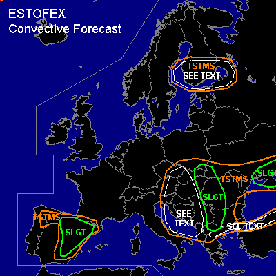
There is a slight risk of severe thunderstorms forecast across Wrn Bulgaria, Wrn Romania, Slovakia, Ern Hungary, Bosnia, Macedonia
There is a slight risk of severe thunderstorms forecast across Spain
There is a slight risk of severe thunderstorms forecast across southern Ukraine
SYNOPSIS
Instability is mostly associated with the high theta-e plume at the east side of an upper cold pool with its core over the Adriatic Sea. Over Spain, a thermal low has developed at the approach of a weak upper trough from the Atlantic. At the south side of these upper lows, upper wind maximum lies over Spain, the Mediterranean and southern Balkan. Another low moves over Finland.
DISCUSSION
...Wrn Bulgaria, Wrn Romania, Slovakia, Ern Hungary, Bosnia, Macedonia...
A couple hundred J/kg MLCAPE is able to be released in the area. Currently, storms are already occurring along the western edge of the theta-e plume, and because of good shear conditions (15-20 m/s 0-6 km and winds veering with height) they may persist for quite a while. Flow pattern seems favorable for training storms, which may cause flash floodings. 00Z soundings have not quite indicated great low-level shear or sr-helicity, but the most crucial area isn't covered... based on GFS 00Z and NMM 00Z models, both are enhanced this afternoon to support also rotating updrafts, while pre-storm LCLs and GFS strong 0-3 km MLCAPE are also quite favourable (below 1200m) to tornadoes, and some large hail.
...southern Ukraine...
00Z Rostov sounding shows steep lapse rates and reasonably good kinematic environment, GFS comes with enhanced SREH, allowing for some strong multicell or perhaps supercell storms, with a risk of large hail.
...Spain...
Madrid 00Z sounding is rather dry, but with steep midlevel lapse rates. La Coruna 00Z shows nice elevated instability which causes a storm last night. Expect that on an isolated but increasing scale (destabilization taking place) storms can develop in the well-defined convergence zone indicated by NMM (and GFS). Given the moderate deep layer shear (~20 m/s) and some slightly enhanced 0-3 km SREH (~150 m2/s2), high-based supercells may be the preferred mode when parcels survive the deep, rather dry boundary layer (high LCLs >2500m). Large hail and severe downburst winds (due to evaporational cooling) will be the main threat.
...Adriatic Sea, western Balkan...
Around the core of the upper low, GFS expects some good low-level instability to be present, especially over the Adriatic and southwestern Balkan. Vertical vorticity may spin up into updrafts, creating spout-type tornadoes.
...northern Turkey, northern Greece...
Dry upper air and some moisture in lower levels with some moist convection possible may lead to very isolated storms, bearing the risk of severe downdraft winds due to evaporational cooling.
...Finland...
Some modest instability confirmed by 00Z Jokioinen, in an environment with 35 kts at 700 hPa may lead to some (cold front) storms with a chance of strong gusts. GFS forecasts LL shear favourable for tornadoes as well.
#