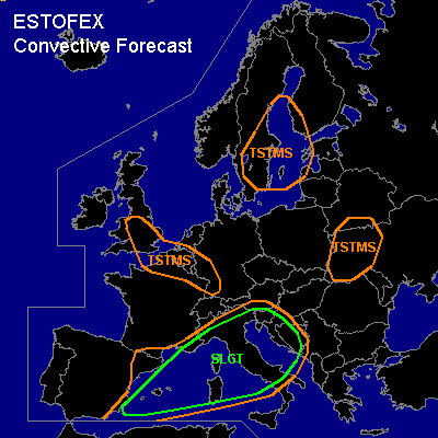

CONVECTIVE FORECAST
VALID Thu 11 Aug 09:00 - Fri 12 Aug 06:00 2005 (UTC)
ISSUED: 11 Aug 08:56 (UTC)
FORECASTER: GATZEN
There is a slight risk of severe thunderstorms forecast across Western, central, and northern Mediterranean, Adriatic
SYNOPSIS
Well-developed upper trough remains over the Baltic Sea. Several vort-maxima travel around the base of this trough ... from British Isles to Germany and further to western Russia. To the south ... well-developed short-wave trough present over Iberian Peninsula travels ENE-ward into northern Mediterranean ... providing DCVA over western and northern Mediterranean. At lower levels ... cool airmass is expected to spread into northwestern Mediterranean in the wake of the upper trough.
DISCUSSION
...Western, central, and northern Mediterranean, Adriatic
...
Latest soundings over southern Mediterranean show steep lapse rates in the range of warm airmass ... with 43K temperature difference between the 950 and 500 hPa level (Cagliari). Rich boundary layer moisture is present over western Mediterranean ... where mixing ratio reaches 16 g/kg in the lowest kilometer (Palma de Mallorca). Rich boundary layer moisture and steep mid-level lapse rates are overlapping over most of western and central Mediterranean .. yielding CAPE values in the range of 2000 J/kg. This unstable airmass is affected by quite strong vort-max indicated by well-developed dark stripe on latest WV satellite images ... reaching from southern Iberian Peninsula to Balearic Islands and further to northwestern Italy. A broad band of clouds is present east of this vort-max ... and thunderstorms have formed from Corsica to northern Italy. On Thursday ... thunderstorms are expected to go on over western and northern Mediterranean. Greatest coverage is forecast over northern Mediterranean/northern Italy ... where CIN should be lower and QG forcing/low-level convergence is expected to be stronger. Thunderstorms that form will have a great potential to be well-organized from Balearic Islands to central Italy and Adriatic ... given deep layer wind shear of 25+ m/s underneath a strong upper jet streak associated with the upper vort-max. Supercells and well-developed multicells/bow echoes are forecast ... capable of producing high winds ... large hail and intense precip. Chance for tornadoes should be enhanced given relatively strong LLS east of propagating surface low pressure system that provides easterly winds over parts of western central Mediterranean. However ... quite strong capping inversion may inhibit tornadogenesis over most places. To the north ... amount of instability is uncertain over northern Italy/Adriatic ... where well-developed frontal boundary is expected to develop during the period. Latest Udine sounding shows relatively rich low-level moisture and CAPE of 300 J/kg, but WAA at mid-levels may lead to decreasing CAPE and increasing CIN during the next hours. However ... strong QG forcing is forecast in the afternoon/evening hours as the upper trough/vort-max approaches ... and thunderstorms are forecast. Although DLS should be lower than to the south ... embedded mesocyclones are not ruled out ... capable of producing large hail, severe wind gusts and a tornado or two. Intense precipitation should be the most significant threat. Thunderstorms should go on during the night and spread eastward, while cool airmass spreads into northwestern Mediterranean ... leading to stabilization. Severe thread should remain during the night as DLS will be strong in the range of the upper jet streak. Allover threat warrants a SLGT risk given expected low coverage of thunderstorms over central Mediterranean and quite low DLS over the northern parts, where widespread convection is forecast. An upgrade to MDT may be needed during the day if convective activity will be stronger over central Mediterranean than expected.
#