CONVECTIVE FORECAST
VALID Wed 10 Aug 11:00 - Thu 11 Aug 06:00 2005 (UTC)
ISSUED: 10 Aug 11:48 (UTC)
FORECASTER: GROENEMEIJER
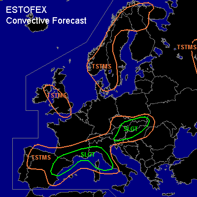
There is a slight risk of severe thunderstorms forecast across northeastern Spain, southeastern France and northwestern and western Italy
There is a slight risk of severe thunderstorms forecast across Slovakia, eastern Austria, northern Hungary, eastern Czech Republic
SYNOPSIS
Wednesday at 12 UTC... a large low pressure area at low, mid- and upper levels is located just northwestest of Estonia. A low at mid levels is located over northeastern Germany and an associated trough extending to northeastern France is expected to move southeastward. Another low pressure system at mid and upper-levels is located over northern Spain. On its southeastern and eastern flanks a strong southwesterly jet at mid- and upper level is present blowing roughly along the Spanish east coast and the northern coast of the western Mediterranean. At low levels, a frontal zone can be identified near this jet, that forms the northern boundary of a very warm air mass over the western Mediterranean.
DISCUSSION
...Spain, southern France, western Italy...
In addition to a couple fo storms that are ongoing over the coastal waters of eastern Spain, isolated to scattered storms are expected to develop further north and northeast during the afternoon and evening. Locally more than 1000 J/kg MLCAPE should be available to the storms and deep-layer shear should be around 20 m/s, so that rotating updrafts are possible as well as bowing segments. The storms have a threat of producing large hail, and damaging winds. An isolated tornado cannot be ruled out either. The coverage of storms may be somewhat limited over most of the risk area, with northwestern Italy likely seeing the highest coverage. The storms will likely continue overnight.
...Slovakia, eastern Austria, northern Hungary, eastern Czech Republic...
Rising motions ahead of the trough presently over Germany will likely allow a few 100's of J/kg CAPE to form over the area. Strong forcing and strong (25-30 m/s) 0-6 km bulk shear is forecast. Hence, it seems likely that a strongly forced linear convective system will form over Austria and the Czech Republic during the afternoon, that will move eastward during the evening and overnight. Strong winds will be the main threat with this system, although isolated large hail and perhaps a tornado or two cannot be ruled out either.
#