CONVECTIVE FORECAST - UPDATE
VALID Tue 09 Aug 15:00 - Wed 10 Aug 06:00 2005 (UTC)
ISSUED: 09 Aug 13:33 (UTC)
FORECASTER: VAN DER VELDE
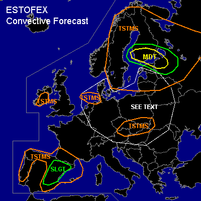
There is a moderate risk of severe thunderstorms forecast across southern Finland, northwestern Russia, Estonia
SYNOPSIS
see Convective Forecast text.
DISCUSSION
...southern Finland, northwestern Russia, Estonia...
Update mainly based upon Jokioinen 12Z sounding - showing 900 J/kg MLCAPE (0-500m parcel), eliminating concerns about degree of instability. The sounding shows also an inversion at 650 hPa, like was also present in 00Z profiles in the warm sector. It will probably erode to a degree at the arrival of upper lift near the cold front. 15 kts ENE, 30 kts ESE at 850 hPa and 40 kts ESE at 500 hPa is a strong kinematic setup, allowing for strong organised convection that should be able to form by the end of the afternoon, probably including a few strong multicell or even supercells (large hail and some tornado threat), building into a squall line ahead of the cold front with bow echo segments that allow widespread severe wind damage. The midlevel dry air seen in the sounding supports this as well, as it allows a strong cold pool to develop. Large hail and tornadoes (low-level buoyancy very strong)will likely occur besides the main severe outflow threat.
12Z St Petersburg and Bologoe shows extreme low-level shear AND low-level buoyancy in the unstable warm sector due to a 55 resp. 45 kts warm conveyor belt at 850 hPa - this very strong horizontal vorticity can cause tornadoes, and downdrafts can transport this to ground as widespread severe gusts... chance of a derecho event developing tonight... *beware*
#