CONVECTIVE FORECAST
VALID Tue 09 Aug 06:00 - Wed 10 Aug 06:00 2005 (UTC)
ISSUED: 08 Aug 22:49 (UTC)
FORECASTER: VAN DER VELDE
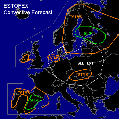
There is a slight risk of severe thunderstorms forecast across southern Finland, northwestern Russia, Estland
There is a slight risk of severe thunderstorms forecast across eastern Spain
SYNOPSIS
A large upper low remains stationary over Europe with its core near Poland. A surface low pressure area deepens in the WAA regime below a shortwave upper trough that swings from Romania at Monday 12Z to Finland Wednesday 00Z. While the warm front sweeps westward over southern Sweden Tue afternoon, a cold front pushes northward over western Russia and the Baltic States, into southern Finland during the evening.
Over Spain, convergence in the thermal low, some moisture and very steep lapse rates provide fuel for thunderstorms. Flow speeds up at the approach of an upper cut-off low.
DISCUSSION
...southern Finland, northwestern Russia, Estland...
Strong >15 m/s low level shear and and moderate deep layer shear within the warm sector ahead of the cold front and enhanced SREH values of generally up to 200 m2/s2 create a powerful setting for severe weather, except that instability will be rather marginal, in the order of 500 J/kg MLCAPE by GFS12Z... which is presently not well indicated by (dry) Mon 12Z Baltic/Russian soundings... so need to be careful. However, strong forcing will be generated at the cold front, probably resulting into a squall line with bow echo segments with a chance of severe gusts. Ahead of the cold front instability is also forecast, with almost no capping in GFS model... but probably also not much lift. May see some isolated storms (possibly mini supercells) ahead of the cold front with a chance of large hail, severe gusts. Overall, tornadoes appear well possible given the strong (low level) shear conditions.
...eastern Spain...
NMM and GFS 12Z models indicate strong convergence in a line over eastern and northeastern Spain by evening, where like the previous day convection may develop. Moisture pool should be richest over northeastern Spain. Deep layer shear over 20 m/s and SREH in generally 100-200 m2/s2 range forecast by GFS and NMM, and low level shear over 7 m/s could well be sufficient for these storms to become supercells, with a chance of large hail and severe outflow winds (especially where LCLs are high/dry environment)
...SEE TEXT area...
broad area, not very specified, near upper low center with locally good low-level buoyancy conditions and steep lower lapse rates could induce spin-up of vertical vorticity in cloud updrafts, especially near convergence lines.
#