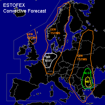
CONVECTIVE FORECAST
VALID Fri 05 Aug 06:00 - Sat 06 Aug 06:00 2005 (UTC)
ISSUED: 04 Aug 17:15 (UTC)
FORECASTER: TUSCHY
There is a moderate risk of severe thunderstorms forecast across parts of Bulgaria
SYNOPSIS
Impressive long-wave trough continues to amplify southward, effecting most parts of northern and central Europe. A second and weaker trough over parts of southeastern Europe will also shift slowly southeastward during the forecast period - both troughs will be the main concern for convective development. Again, the western Mediterranean area will see hot and stable conditions.
DISCUSSION
...parts of Bulgaria...
Slowly eastward moving cold front is forecasted to stall somewhere over central Bulgaria and start to retreat as a warm front in the evening hours...Airmass ahead of this frontal system will be very dry ( like seen yesterday in the sounding reports of Izmir [04. August 12Z])...Models forecast broad low-level depression development south of Bulgaria and this development should enhance low-level shear...GFS showed up to 12m/s low-level shear, accompanied with about 15 to 20m/s deep layer shear and enhanced SRH values...Main development will occur along the frontal boundary, but also expect cell development over the eastern part of Bulgaria, where conditions are favorable for discrete storm development with a threat for very large hail and severe wind gusts...LCL's quite high, but each storm, rooting in the boundary layer will have an augmented risk to produce a tornado.
Widespread TSTM initiation should occur along the frontal zone with main risk being large hail, severe wind gusts and also a chance for a few tornadoes, given enhanced low-level shear...Later in the period, storms will cluster with a risk for torrential rain and therefore flash flooding
...northwestern Germany,Belgium and the Netherlands...
Main feature of interest will be occluded frontal system, which should cross the SEE TEXT area from northwest to southeast and will be accompanied by a weak trough...Ahead of this disturbance, a tongue of higher THETA-E values will reach the area and small instability values can be materialized...Forcing should be enough for isolated to scattered storm initiation along the frontal boundary... Although thermodynamic conditions are only marginal favorable, strengthening wind field, caused by entering jet streak, should increase deep layer shear values ( in the order of about 20m/s)...Developing storms will pose a risk for isolated severe wind gusts and marginal hail.
Postfrontal forecast soundings also show the possibility for marginal instability release and isolated convection development should occur with main risk being severe wind gusts in an environment with up to 35m/s deep layer shear.
#