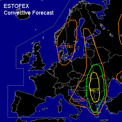

CONVECTIVE FORECAST
VALID Thu 04 Aug 06:00 - Fri 05 Aug 06:00 2005 (UTC)
ISSUED: 03 Aug 21:08 (UTC)
FORECASTER: GATZEN
There is a moderate risk of severe thunderstorms forecast across southwestern Ukraine, central and western Romania, western Bulgaria
There is a slight risk of severe thunderstorms forecast across a region surrounding the MDT risk region
SYNOPSIS
Upper long-wave trough dominates northwestern Europe, and cool maritime airmass has spread into northwestern, northern, and central Europe. Relatively warm airmass and unstable is present in the range of a upper high over eastern Europe. A short-wave trough slowly digs northeastward over northern Mediterranean/Balkans ... providing QG forcing over southeastern Europe. At the surface ... a cold front is expexted to cross the Balkans on Thursday.
DISCUSSION
...Balkans, Black Sea region, eastern Europe
...
Warm and locally very unstable airmass is present over southeastern Europe ... characterized by steep mid-level lapse rates and rich low-level moisture ... creating CAPE values in the order of 2000 J/kg as indicated by latest ascends. On Thursday ... a cold front is forecast that moves eastward over the Balkans east of a high pressure system over western and central Europe. To the east of the cold front ... models indicate low-level convergenze from central Greece to eastern Poland. Aloft ... axis of upper short-wave trough/vort-max travels northward over Balkans and Black Sea region ... and DCVA should lead to QG forcing. Downstream ... a relatively strong jet streaks propagates northward from western Romania to Baltic Sea. On Thursday ... diurnal heating and low-level convergence should lead to initiation along and east of the cold front. Thunderstorms that form will likely organize over eastern Serbia, western Bulgaria and Romania, and western Ukraine given DLS up to 25+ m/s as indicated by latest GFS model run. Supercells should form capable of producing large hail and severe wind gusts. Although latest observations do not show very moist boundary layer airmass ... and LCL heights may be not favorable over most of the region ... a few tornadoes are not ruled out given quite strong LLS along the convergence line ... exceeding 12 m/s as indicated by latest GFS model run. Thunderstorms should merge into one or two MCS along the convergence line or cold front. Severe wind gusts and intense precip should be the main threat during the evening/night hours. To the east ... models suggest stabilization over western Black Sea region due to warm mid-level airmass advecting northward and weak QG forcing ... however ... it is not ruled out that one or two isolated severe thunderstorms will occur. Severe wind gusts and large hail should be the main threat given quite strong capping inversion and high cloud base.
#