CONVECTIVE FORECAST
VALID Wed 03 Aug 06:00 - Thu 04 Aug 06:00 2005 (UTC)
ISSUED: 02 Aug 20:41 (UTC)
FORECASTER: GROENEMEIJER
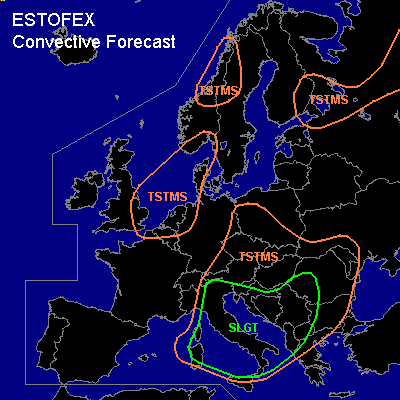
There is a slight risk of severe thunderstorms forecast across Italy, southern Alps, western and central Balkans
SYNOPSIS
Wednesday at 06 UTC... an intense low at mid-levels over Corsica is expected to move eastward to the central Adriatic during the forecast period. Ahead of an eatward moving cold fron, initially from Slovenia to northwestern Tunisia, a very warm air-mass with a deep elevated mixed layer flows northward.
DISCUSSION
...Italy, southern Alps, western and central Balkans...
Around 1000 J/kg MLCAPE is expected ahead of the cold front per GFS and NMM models. Scattered convective storms are expected to form near and ahead of the front early Wednesday morning over northern, northeastern, central and southern Italy.
Deep-layer wind shear of around 20 m/s in the northeast to around 30 m/s in the south and storm-relative helicity of a round 200 m2/s2 should be adequate for the development of supercells. These should be able to produce large hail and damaging winds, with the highest threat likely in the south. Given the strong forcing for upward vertical motion, the storms are expected to cluster quite rapidly into larger MCS's.
During the day, the severe threat is expected to shift further eastward and southward along with the moving cold front to southern Italy, southern Croatia and during the evening to the central Balkans and Albania.
#