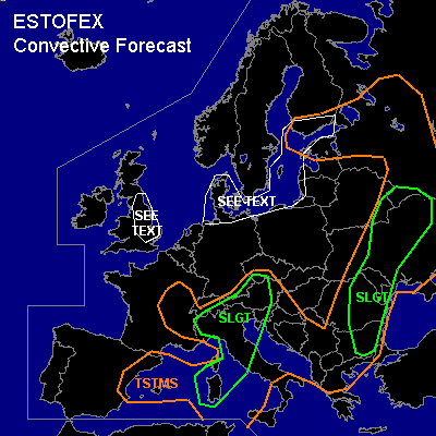

CONVECTIVE FORECAST
VALID Tue 02 Aug 06:00 - Wed 03 Aug 06:00 2005 (UTC)
ISSUED: 02 Aug 04:31 (UTC)
FORECASTER: VAN DER VELDE
There is a slight risk of severe thunderstorms forecast across Nrn Italy, Alpine region into Czech Rep.
There is a slight risk of severe thunderstorms forecast across eastern Balkan into Ukraine
SYNOPSIS
Upper trough shifts from Iberian Peninsula to Mediterranean and Italy, enhancing instability aloft.
DISCUSSION
...Nrn Italy, Alpine region into Czech Republic...
Strong deep layer shear created by 500 hPa 40 kts and veering winds with height cause a good enviroment for supercells and MCS storms, with primary threats if large hail and gusts. LL shear is on the marginal side and best in Alpine area... enhancing tornado chance more. Alpine area could see SREH values up to 300 m2/s2. 00Z soundings have indicated dry air over southern portions of the SLGT area but with a chance of elevated convection. These may cause severe gusts... the strong shear and SREH will not be too effective for rotating updraft generation in this case.
...Romania, Bulgaria, Moldova, Ukraine...
Except for Ukraine, not much shear will be present in the area, but MLCAPE should be enhanced to 1000-1500 J/kg, sufficient for large hail, on isolated basis given not much organised trigger (i.e. mountains).
In Ukraine GFS has much enhanced SREH to offer, along what seems a wave, so this may be good for organised convection into MCS or supercells. DL shear is not quite as enhanced as over Italy, but LL shear is... seems that tornadoes could be possible from supercells tending to HP.
...Ern UK, Denmark, Baltic Sea...
00Z soundings have shown strong low-level buoyancy and steeo lapse rates, with EL around 3 km and very weak winds throughout. This is particularly notorious for generating (water)spouts, by stretching of vertical vorticity (e.g. convergence lines) into strong updrafts.
#