CONVECTIVE FORECAST
VALID Mon 01 Aug 07:00 - Tue 02 Aug 06:00 2005 (UTC)
ISSUED: 01 Aug 07:40 (UTC)
FORECASTER: GROENEMEIJER
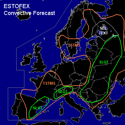
There is a slight risk of severe thunderstorms forecast across Belarus, Ukraine, Russia, much of the Balkans, parts of northern Italy, southeastern France and across eastern Spain
SYNOPSIS
Monday at 06 UTC... a southwesterly mid- and upper-level flow is present over much of Europe, downstream of a trough over the Bay of Biscay and western Iberia. This trough is expected to move slowly eastward and intensify. A baroclinic wave located over the Polish/Belorussian border is expected to move quickly eastward.
DISCUSSION
...Belarus, Ukraine, Russia...
Within the warm sector of a baroclinic wave, a series of MCS's is ongoing across central and southwestern Belarus and the extreme western Ukraine. They pose a threat mainly of damaging winds, especially with the northernmost MCS that may well have a bow-echo structure. Convection is expected to become surface-based later today as the boundary-layer warms, increasing the threat for damaging winds expecially across much of Belarus, and the Smolensk area.
Moderate to strong deep-layer bulk shear of 15-20 m/s in the 0-6 km layer, and large amounts of latent instability locally around or in excess of 2000 J/kg MLCAPE (per GFS and L'vov 00Z sounding) should become available, so that convective modes will likely (still) include supercells and bow-echoes after surface-based convection initiates later today.
Convection is expected to develop further to the southwest along the trailing cold front (near a line from near Smolensk to a few 100s of kms south of L'vov) during the afternoon. The storms pose a threat of large hail, flash floods, damaging winds and perhaps a tornado or two.
...Balkans...
Only low to moderate shear is expected across the area but considerable CAPE of around or above 2000 J/kg MLCAPE are expected to form in places. Isolated to scattered storms are expected to form during the afternoon and early evening. These will have main threats of locailized downbursts and large or very large hail, although an isolated spout-type tornado may be possible as well.
...northern Italy...
Around 1000 J/kg MLCAPE is expected form over the Po-Valley later today. Considering that deep-layer bulk shear around 20 m/s is expected over the area, any convective storms that form may well become supercells or bowing systems capable of producing large hail and strong winds. Storms are expected to initatiate during the early afternoon and may continue overnight, although the severe threat should decrease as the boundary-layer cools.
...eastern Spain, adjacent part of France...
Strong deep-layer bulk shear of 20-30 m/s in the 0-6 km layer and up to around 1000 J/kg MLCAPE are expected this afternoon across eastern Spain, creating a favourable environment for supercell storms. Lift expected to affect the area ahead of an intensifying trough over western Iberia is forecast to aid the development of scattered surface-based convective storms later today. Supercells with a threat of large hail, strong winds, local flash floods and perhaps a tornado will likely affect the area later today. The storms may congeal into a larger MCS over northeastern Spain later on. The storms will likely weaken gradually during the late evening and overnight as they become elevated.
...southeastern Finland, adjacent parts of Russia...
Around 500 J/kg weakly-capped MLCAPE is expected to form across the area this afternoon. In combination with 15-20 m/s of deep layer shear, well-organized multicell storms are forecast to form across the area during the later morning and early afternoon. Some marginally large hail and gusty winds are possible with these storms. Threat is enhanced when a few rotating updrafts manage to form.
#