CONVECTIVE FORECAST - UPDATE
VALID Sun 31 Jul 12:00 - Mon 01 Jul 06:00 2005 (UTC)
ISSUED: 31 Jul 14:38 (UTC)
FORECASTER: VAN DER VELDE
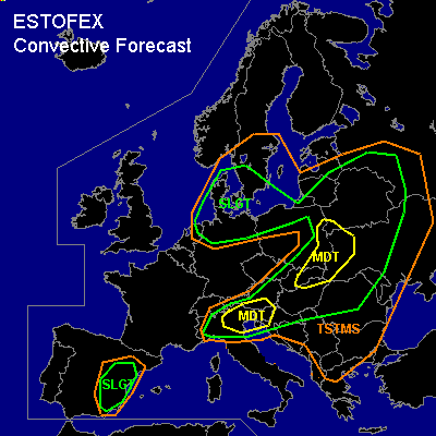
There is a moderate risk of severe thunderstorms forecast across Slovakia and eastern Poland into Belarus/Ukraine
There is a moderate risk of severe thunderstorms forecast across Northeastern Italy and Slovenia
There is a slight risk of severe thunderstorms forecast across Denmark, southern Sweden, northern Germany, northern Poland, eastern Europe
There is a slight risk of severe thunderstorms forecast across eastern Spain
SYNOPSIS
In the very unstable air east of a cold front from northern Italy to Belarus, scattered severe thunderstorms will develop under moderate to high shear conditions. Near the occluded parent low over Denmark, instability is also present in enhanced shear environment.
DISCUSSION
...northern Italy and Slovenia...
12Z soundings show around 3000 J/kg MLCAPE in Udine, with dewpoints reaching 22-24 degrees in METARs - at least twioce as much CAPE as GFS 06Z has forecast. This is accompanied by veering winds in the lower levels to 40 kts at 500 hPa, and dry midlevels, also in Milano 12Z. This creates possibility for supercell thunderstorms with severe downbursts, very large hail and possibly a tornado.
...Slovakia into eastern Poland...
An upper shortwave is forecast by GFS 06Z to pass the region, while strong instability and shear are present, as already indicated by 00Z Prostejov... that led to a large MCS/MCC bow echo system over Poland last night. The warm air is being pushed away only tonight, giving a second chance of widespread convection over this area. SREH values up to 100-300 m2/s2 range and MLCAPE in 1000-2000 J/kg range can proceed into supercells and bow echo MCS storms, with a chance of isolated very large hail, severe widespread gusts, and with LL shear enhanced locally to over 10 m/s, also tornadoes.
...Denmark, Srn Sweden, Nrn Germany, Nrn Poland...
As 00/12Z ascents have indicated, several hundreds J/kg CAPE without much capping are available over a large area, while low level shear can reach well over 10-15 m/s. This promotes the chance of several tornadoes. In extreme NW Poland, a supercell was already observed this early afternoon. Additional threat is isolated large hail and gusts. In the northern part of this area, shear is less and strong low level buoyancy/lapse rates can instead provoke tornadoes by spin-up processes along low-level vertical vorticity sources.
...eastern Spain...
Part of this area will stay capped, but midlevel lapse rates are strong and moisture is being advected from the east in lower levels, while a 40-50 kts jet at 500 hPa blows in from the west. Strong deep layer shear is the result. Any storms could develop rotation and large hail, also severe gusts and possibly an isolated tornado, though because of the cap there will likely not be too many storms.
#