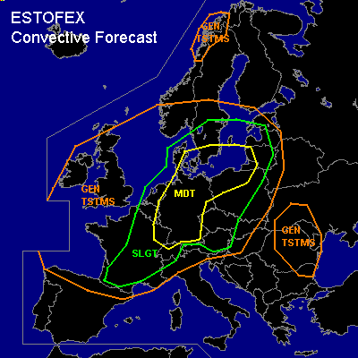
CONVECTIVE FORECAST - UPDATE
VALID Fri 29 Jul 15:00 - Sat 30 Jul 06:00 2005 (UTC)
ISSUED: 29 Jul 14:43 (UTC)
FORECASTER: TUSCHY
There is a moderate risk of severe thunderstorms forecast across Germany, extreme northwestern Switzerland,northwestern Poland, parts of Lithuania and Latvia, southern Sweden and parts of Denmark
SYNOPSIS
Please refer to synoptic discussion at 28 Jul 21:19 (UTC) !
DISCUSSION
...Germany, extreme northwestern Switzerland,northwestern Poland, parts of Lithuania and Latvia, southern Sweden and parts of Denmark...
No change for MDT risk area, discussed at 28 Jul 21:19 (UTC).
Models have some problems with convection development over parts of Germany, so went with a significant expansion of the MDT area further to the southwest...Broad area of TSTMs developed during the past few hours over southern and southeastern France...latest sounding reports over Germany show quite high CAPE values over central, eastern and southeastern Germany.... Relatively dry boundary layer and steep mid- and low level lapse rates are present over this area....Satellite loops show short wave entering the MDT area in the next few hours and widespread storm initiation can be expected... Especially over southern and central Germany, conditions area favorable for storm organisation with an attendant threat of very large hail,an isolated tornado and severe wind gusts....
A trend was noticed of a westward shift of convective signals in the evening hours by some models over northwestern Germany....this would place the storms under an entering jet from the southwest with increasing deep layer shear....Development of bowing segments with an enhanced severe wind threat will be possible....shower and TSTM activity during the noon and afternoon hours over western Germany also helped to moisten the atmosphere furthermore, so lower LCLs expected....this could locally enhance the tornado threat in areas, where low level wind field will be modified ( by topography).... slow propagation of front and strong southwesterly jet should produce an area of training storm development over the western part of Germany with the possibility for torrential rain, so flash flooding possible.
#