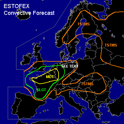

CONVECTIVE FORECAST
VALID Wed 27 Jul 09:00 - Thu 28 Jul 06:00 2005 (UTC)
ISSUED: 27 Jul 09:13 (UTC)
FORECASTER: GATZEN
There is a moderate risk of severe thunderstorms forecast across northern France, Benelux, extremely western Germany
There is a slight risk of severe thunderstorms forecast across western and central France, southern England, Benelux, and western Germany
SYNOPSIS
Northern African subtropical high ridges into central Mediterranean and Balkans. In the range of this high ... warm airmass is present, characterized by relatively steep mid-troposphere lapse rates. To the west ... rather sharp long-wave trough is present with an axis reaching from northern North Sea to northwestern British Isles and further southward into Atlantic Ocean W of Iberian Peninsula ... sustained by a short-wave trough that propagates from northern British Isles southward. At the surface ... well-developed low-pressure system W of Iberian Peninsula evades northward over western Bay of Biscay. Associated warm front is expected from southern British Isles to southern Baltic Sea on Thursday ... and strong WAA is expected over most of western/central Europe ... while a cold front enters western Iberian Peninsula late in the period.
DISCUSSION
...France, Benelux, southern England, western, northern, and central Germany
...
A intense WAA regime is present over western Europe east of the surface low-pressure system over western/northern Bay of Biscay/western Channel. Elevated mixed layer is present over southern France/northern Spain as indicated by latest ascends ... that advects northward during the day. At lower levels ... rich boundary layer moisture has built over western and central France, where mixing ratios of 11-14 g/kg were measured ... leading to instability ... and thunderstorms have already formed from Bay of Biscay to western/central France. During the day ... insolation is expected south of the warm front over southern and central France ... and strong instability should result. Models show that this unstable airmass spreads northward into northern France, southeastern England, Benelux, and western Germany during the day. Aloft ... strong SW-erly flow is present over most of western Europe. An unseasonably strong upper jet streak /30+ m/s @ 300 hPa/ visible on latest WV satellite image from southwestern Iberian Peninsula to Bay of Biscay is forecast to move eastward over France during the period ... providing strong DCVA that should result in quite strong QG forcing over Bay of Biscay ... western/northern France ... southern British Isles ... and Benelux. Thunderstorms are expected to go on over western/central France ... spreading northward in the range of the WAA regime over northern France/southern British Isles during the period. Later in the day ... thunderstorms should also develop over central France in the range of the upper jet streak/vort-max and along the WAA regime over Benelux/western Germany. Thunderstorms will likely organize given strong deep layer wind shear. Multicells and supercells are forecast capable of producing large hail and severe wind gusts. In the afternoon/evening hours ... models show increasing DLS exceeding 25 m/s in the range of the WAA regime over northern France, Benelux, and western Germany ... where easterly low level winds are expected ... and chance for severe weather should increase. Very large hail and damaging wind gusts are not ruled out. Chance for tornadoes should increase during the day as LLS is expected to increase over northern France, southern British Isles, Benelux, and western Germany ... reaching more than 15 m/s late in the period as indicated by latest GFS model run. Long-lifed tornadic supercells are not ruled out ... capable of producing strong tornadoes over northern France/Benelux. Thunderstorms should merge into a few MCS during the evening ... moving NE-ward into southern British Isles, northern and central Germany. Widespread severe wind gusts and intense precip/flash flooding are forecast. Thunderstorms should reach eastern Germany/Poland during the night/morning hours ... where a few severe events are not completely ruled out given 15+ m/s DLS.
#