CONVECTIVE FORECAST
VALID Tue 26 Jul 06:00 - Wed 27 Jul 06:00 2005 (UTC)
ISSUED: 26 Jul 08:18 (UTC)
FORECASTER: VAN DER VELDE
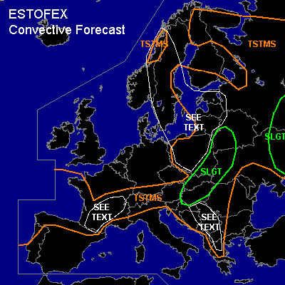
There is a slight risk of severe thunderstorms forecast across Hungary, Slovakia, SErn Poland, Wrn Ukraine, Wrn Belarus
There is a slight risk of severe thunderstorms forecast across Russia, Ern Ukraine
SYNOPSIS
Low pressure cores are situated over southern Scandinavia and west of the Iberian Peninsula. A jetstream stretches from southern Germany into Belarus. Most instability is present just south of the frontal zone, from central France into the northern Balkan and the Baltic States.
DISCUSSION
...Hungary, Slovakia, SErn Poland, Wrn Ukraine, Wrn Belarus...
Strong upper winds in combination with some instability (GFS 0-1 km parcel MLCAPE 200-1200 J/kg) and lift along the frontal zone are favourable for organised thunderstorms with a risk of strong gusts and large hail. GFS model predicts enhanced SREH (>100 m2/s2), DL shear (>15 m/s) and LL shear (>10 m/s) over the southeastern corner of Poland, western Ukraine and Slovakia this afternoon. Especially in this area organised multicells and supercells will be likely to develop. 00Z soundings in the west part of the area confirm a strong kinematic environment with around 50 kts at 500 hPa and marginal latent instability. A tornado is not ruled out especially in the smaller area decribed above.
...Russia, Ern Ukraine...
00Z soundings indicate an unstable environment (up to 1000 J/kg) with strong upper winds (e.g. 30 kts @ 700 hPa) over this area. Locally moderate to strong vertical shear can promote organisation of strong multicell and supercell storms... the latter is most likely near the warm front in the northern part of the SLGT area, where SREH and shear are enhanced according to GFS-18Z. Large hail, gusts and an isolated tornado are expected. The lift should come from convergence within the thermal low.
...SEE TEXT over Baltic Sea and surroundings...
Fairly good low-level instability and lapse rates and a weak kinematic environment will likely spawn a number of weak spout-type tornadoes, especially where there is a concentrated source of vertical vorticity, such as convergence lines.
...SEE TEXT over Balkan...
Dry, steep lapse rate environment may locally allow convection to develop, which may have an enhanced threat of severe gusts due to strong evaporative cooling by surrounding dry air entraining into a storm.
...SEE TEXT over France...
Marginal MLCAPE is forecast by GFS-18Z model, and some elevated instability. As vertical shear conditions are marginal to induce updraft rotation (SREH enhanced to over 100 m2/s2, DL shear around 15 m/s), expect some storms to become well organised, perhaps developing rotation. These will have an enhanced threat of large hail and strong gusts. There is not much flow through the region, nor large scale forcing, which limits the chance of a mesoscale convective system, as also does the only marginal instability.
#