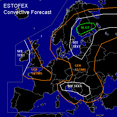
CONVECTIVE FORECAST
VALID Fri 22 Jul 06:00 - Sat 23 Jul 06:00 2005 (UTC)
ISSUED: 21 Jul 18:22 (UTC)
FORECASTER: TUSCHY
There is a slight risk of severe thunderstorms forecast across Central Finland
SYNOPSIS
Low index pattern established over Europe. Broad upper level low over the Baltic Sea should move northeastward during the forecast period, while another upper level disturbance west of Ireland will shift eastward towards Europe. To the South, over the Mediterranean area and most parts of southeastern Europe, higher geopotential heights will lower convective activity.
DISCUSSION
...Central Finland...
Last model runs pretty consistent in developing a weak low pressure area east of Finland, shifting westward. Strength of this system important, because this will decide how much of the warmer and more humid airmass over central Russia will be advected towards the rsik area...Current thinking is that advection / wrap-around moisture should be enough for slight destabilisation of the atmosphere in the order of 100 - 200 J/kg....Low level shear up to 12m/s, 0-1km SRH values of about 250 m**2/s**2 and low LCLs will pose a risk for a few tornadoes, especially along numerous frontal boundaries....Deep layer shear up to 15m/s will be conducive for multicellular storm mode, so expect highest tornado risk at the beginning of TSTM initiation. Deep warm cloud layer, high PWAT values and slow storm motion will pose a risk for locally torrential rain and therefore flash flooding.
Further to the east, northward moving cold front and moderately unstable airmass in advance of this front should create a favorable environment for scattered to widespread TSTM development...Weak kinematic parameters won't favor a severe risk, but locally flash flooding could occur with each storm ( high PWAT values).
Under the base of the upper level low [ Baltic Sea region ], conditions will be favorable for isolated spout development.
...Parts of SE Europe...
Broad upper level trough should shift southeastward over the Alpine regions towards the area of interest. Accompanying cooler mid level airmass should help to further destabilisize the atmosphere in the order of 200 - 400 J/kg...ATM, best thermodynamic and kinematic areas are separated, but models show numerous pieces of wind energy, so there will be the possibility for a few more organized storms...main threat will be an isolated severe wind gusts and marginal hail.
...Ireland, southwest Great Britain and north central France...
Upper level disturbance shifts eastward and cold front will arrive in the afternoon hours over western Ireland. Best area for organized storms will be southern Ireland and further southward, because of a stronger wind field [strong jet ejecting out of the base of the disturbance ]. A few severe wind gusts possible if MCS can develop.... further northward, global models show weak shear environment, but backing winds in the low levels could enhance the low level shear slightly...this in mind, combined with low LCLs, don't want to exclude the chance for one or two tornadoes over the rest of Ireland....Because the depression will switch back towards a positive tilt, cold front will slow down in forward propagation and current thinking is, that only southwest Great Britain should see isolated storm initiation.
France will be under weak ridging during the forecast period, but during the night hours,a thermal trough should cross northern France...Bad timing of this trough and only faint cooling in the upper levels won't favor TSTM initiation, but weak forcing, forecasted from some models, could help to overcome the cap...so included parts of France in the GEN TSTM area...There will be a marginal hail risk, if storms develop.
#