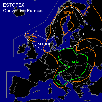

CONVECTIVE FORECAST
VALID Tue 19 Jul 06:00 - Wed 20 Jul 06:00 2005 (UTC)
ISSUED: 19 Jul 02:09 (UTC)
FORECASTER: VAN DER VELDE
There is a slight risk of severe thunderstorms forecast across Poland, Ern Germany, Czech Republic, Slovakia, Nrn Balkan, Wrn Ukraine, part of Italy
SYNOPSIS
A low pressure system near Scotland/northern North Sea steers cooler maritime air into western Europe, pushing into warm airmass over the eastern half of Europe. At the start of the FCST period, DCVA and the cold front in sfc low pressure are progged to move through Germany and down into Italy and trigger storms in the slightly unstable airmass (MLCAPE 200-1000 J/kg) that move eastward into Poland and the Balkan, respectively. Unstable airmass is also present over Scandinavia and the Baltics, in generally weak eastern flow without dynamical features.
DISCUSSION
...Eastern Germany, Poland, Czech Rep. and Slovakia...
As DCVA and band of enhanced moisture (>10-11 g/kg avg lowest 1 km) ahead of the cold front (in GFS) move through the area by noon to evening, a line of storms is expected to develop that may configure as a squall line, in a moderate DL shear (10 m/s), moderate to fairly strong LL shear (7-12 m/s) environment. As instability and shear are not so great, expect some low-end severe weather, including gusts, marginally large hail and perhaps an isolated tornado.
...Italy, northern Balkan into Ukraine...
More shear will be present over these parts, even 0-3 km storm-relative helicity (SREH) will be enhanced in some areas to over 300 m2/s2 in presence of a few hundred J/kg MLCAPE, which can certainly generate a few supercells and organise an MCS. Synoptic scale support is strong at the east side of an upper trough near the jetstream, and widespread convection should result. Primary threats should be severe gusts, especially from bowing storm segments that are anticipated, large hail and a few tornadoes are very well possible. The main area of interest with also several tens of mm convective precip is the area from Slovakia, SErn Poland into Ukraine, near a SFC low pressure core.
...Scotland, North Sea, Baltic Sea, Scandinavia and Baltics...
Especially within the drawn area of strongest low-level lapse rates, decent 0-3 km CAPE and fairly weak kinematics, spout-type tornadoes could form where locally vertical vorticity could be stretched into an updraft. Also, storms over Scandinavia and the Baltic states could move very slowly, with a local flash flood threat.
#