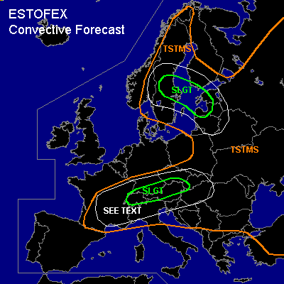

CONVECTIVE FORECAST
VALID Sat 16 Jul 09:00 - Sun 17 Jul 06:00 2005 (UTC)
ISSUED: 16 Jul 09:42 (UTC)
FORECASTER: GATZEN
There is a slight risk of severe thunderstorms forecast across northern Alpine region
There is a slight risk of severe thunderstorms forecast across Central Baltic Sea region, southern Sweden, Finland and western Baltic States
SYNOPSIS
A relatively intense upper trough present over southern Scandinavia slowly digs northeastward. A its southeastern flank ... a short-wave trough/vort-max travels northeastward over Poland ... and strong northwesterly upper jet streak over Germany evades into western Poland. To the north ... strong QG forcing is expected over central Baltic Sea region. Over southeastern Europe ... upper trough starts to migrate northward at the eastern flank of the Scandinavian trough ... providing DCVA over Ukraine. Over the Atlantic Ocean ... a intense polar trough propagates southeastward ... and upper cut-off west of Iberian Peninsula starts to turn northeastward at its southeastern flank. At lower levels ... cold maritime airmass has spread into British Isles, North Sea region, northern Germany, and southern Scandinavia in the range of the Scandinavian trough. South and east of a cold front that is expected from central France to northern Alps and further to eastern Poland, and western Baltic states ... rather warm and moist airmass is present over most of Europe. This airmass is characterized by well-mixed mid-levels ... and rather rich boundary-layer moisture is present from France to Alpine region and over most of eastern and southeastern Europe ... leading to CAPE over a broad region.
DISCUSSION
...Northern Alpine region
...
South of the propagating cold front over Germany ... rather strong low-level westerly flow is present over northern Alpine region ... and WAA is forecast. This airmass is characterized by steep lapse rates above the boundary layer ... as indicated by latest Payerne ascend (30K difference between 850 and 500 hPa level). In the range of this WAA-regime ... elevated thunderstorms have already formed over southern Germany ... moving eastward into Austria during the next hours. During the day ... low-level moisture advection from western Alpine region is expected north of the Alps ... and CAPE should reach around 1000 J/kg locally. Although QG forcing should remain relatively weak west of the trough axis ... thunderstorms should go on during the day while chance for surface-based convection should increase due to daytime heating/low-level moisture increase. Thunderstorms that form may be severe given around 15 m/s deep layer wind shear ... capable of producing large hail and severe wind gusts locally. Later in the day ... westerly winds are expected to increase along the Alps south of the cold front ... and low-level wind shear should exceed 10 m/s as indicated by latest model output (GFS/NMM). Increasing low-level helicity and quite low LCL heights should enhance the chance for tornadic supercells ... and a few tornadoes, some of them may be strong, are forecast. However ... storm coverage and intensity remains questionable ... given actual cloud coverage and probably weak forcing in the afternoon/evening hours. Actual thinking is that a weak vort-max shown by GFS will travel eastward during the evening and may provide QG forcing. An upgrade to MDT may be required if storm coverage will be greater than expected.
...Central Baltic Sea region, southern Sweden, Finland and western Baltic States
...
At the northeastern flank of the Scandinavian trough ... strong upper vort-max/short-wave trough moves northward into central Baltic Sea. At lower levels ... warm and unstable airmass characterized by quite rich low-level moisture and weak CIN advects northwestward northeast of a cold front moving northeastward over the Baltic Sea today. Strong QG forcing is expected to the northeast and along the upper trough axis/associated cold front. Thunderstorms/MSC have already formed over the Baltic Sea in the range of the WAA regime. On Saturday ... convective activity is expected to spread into Sweden, Baltic states, and southern Finland. Greatest potential for organized severe convection is expected in the range of upper jet streak reaching from Baltic States to central Baltic Sea and eastern Sweden ... where deep layer vertical wind shear is expected to reach 20 m/s. Thunderstorms should merge into a few MCS and bowing lines ... capable of producing severe wind gusts. North of the cold front ... enhanced low-level helicity is forecast by latest GFS model run ... and supercells are not ruled out ... capable of producing large hail and probably a tornado or two. Allover thread seems to be lower than on Friday over Germany.
...Southern France, Alpine region, northern Italy, northwestern Balkans
...
Warm and unstable airmass is present from southern France to Alpine region and northern Balkans ... and thunderstorms are expected to initiate during the day. Some thunderstorms may be severe given 15+ m/s deep layer wind shear in the range of the westerly jet south of the Scandinavian trough. Large hail and severe wind gusts should be the main threat ... as well as local flash flooding. As QG forcing will be weak ... expect only isolated thunderstorms over France, and northern Italy. Best chances seem to exist over the Alpine region. Allover threat should be significantly lower than over northern Alpine region.
#