CONVECTIVE FORECAST - UPDATE
VALID Fri 15 Jul 14:00 - Sat 16 Jul 06:00 2005 (UTC)
ISSUED: 15 Jul 14:05 (UTC)
FORECASTER: GROENEMEIJER
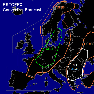
There is a slight risk of severe thunderstorms forecast across much of Germany, southern and southeastern Sweden, northeastern France, the southeastern and eastern Benelux, northern Switzerland, western Czech republic and northwestern Poland.
SYNOPSIS
refer to convective forecast...
DISCUSSION
...Germany, northwestern Poland, Sweden, Netherlands...
Ahead of a cold front, analyzed from near Kiel to Saarbrücken a warm and dry air-mass is in place over much of Germany. Wind profiles showing 15-20 m/s deep-layer shear and a few 100s of J/kg MLCAPE have proven to be sufficient for some ornganized storms - including possible supercells - to form over northern and cnetral Germany. The main threats of the storms are large hail and strong downbursts. Behind the cold front, over northwestern Germany and the eastern Benelux, additional strong storms may form as instability and rather strong dee-layer shear are present there as well.
The storms will likely cluster more during the next few hours.
Numerical models show the potential for a severe MCS to develop over eastern Germany, that moves northeastward and may affect southeastern Sweden during the evening hours and overnight. Main threat of such a system would likely be damaging winds, although some large hail and an isolated tornado or two could be possible as well.
...France, Switzerland, southern Germany, Czech Republic...
Increasing warm advection over southwestern Germany, northern and eastern France is expected to aid in the initiation of scattered storms during the coming hours. Shear is expected to increase strongly on the apporach of a jet streak over the Channel region to values around 25 m/s across the 0-6 km layer. Supercells with a threat of large hail and damaging downbursts are expected to form over northeastern France, southern Belgium and Luxemburg southern Germany and Switzerland during the remainder of the afternoon and evening. These may well turn into one or more bowing convective systems with a main threat of damaging winds, that move eastward during the evening and into the night.
#