CONVECTIVE FORECAST
VALID Fri 15 Jul 06:00 - Sat 16 Jul 06:00 2005 (UTC)
ISSUED: 14 Jul 17:33 (UTC)
FORECASTER: TUSCHY
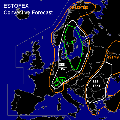
There is a slight risk of severe thunderstorms forecast across Central and southern Sweden,western and central Poland
There is a slight risk of severe thunderstorms forecast across Switzerland and southern Germany
SYNOPSIS
Complex weather pattern over Europe. Main feature of interest will be a strong trough, swinging eastward over the North Sea. Downstream of this feature, strengthening WAA helps to fill the broad, but shallow trough over eastern Europe, which should be nearly stationary during the forecast period...another weak trough in front of Spain and the WAA of first trough ( North Sea ) should help to establish a ridge over most parts of the Mediterranean area, suppressing convective development.
DISCUSSION
...Central and southern Sweden,western and central Poland...
Generally, all models agree in the development of strong convection in the risk area, although some areas have to be monitored separately...During the morning hours of Friday, developing low level depression over parts of Norway should shift eastward and could produce a broad area of backing winds in its NE quadrant over central Sweden....Current model runs show an increase in low level shear and forecast soundings from this area show strong veering profilers....Instability not impressive ( generally about 300 J/kg )but expect strong forcing by cold front and low LCLs...models show low level shear up to 12m/s, but strong modification by topography could locally enhance those values. This should be enough for the chance for a few tornadoes and locally severe wind gusts....Only inhibiting factor could be missing insolation and hence even lower instability values.
Further south, we should see an increase in instability with up to 700 J/kg, deep layer shear about 20m/s over southern Sweden and up to 10m/s low level shear over north eastern Poland....Strong cold front,left exit region of developing 500hPa jet and weakly capped environment should allow for widespread TSTM development...Current thinking is that storms will develop along cold front or anticipating wind shift line and strong to severe MCS will move eastward. Expect severe wind gusts and a locally enhanced tornado threat along the line ( low LCLs and veering forecast soundings) being the main risk....line of storms also moves in an high PWAT tongue over parts of Poland and there will exist a risk for flash flooding ....Main reasons for not upgrading ATM are uncertainness of insolation and strength of deep layer shear...but may be necessary later in the period.
Backbuilding/developing storms along the cold front should also effect parts of northern and central Germany, but weaker deep layer wind shear should limit the severe weather threat....Instability in the order of 500J/kg, steep low level lapse rates and up to 10m/s low level shear should be enough for an isolated large hail threat and a locally enhanced risk for severe wind gusts....Threat too marginal for expanding risk area farther southwestward ATM.
...Switzerland and southern Germany...
Base of the North Sea trough will arrive in the late afternoon hours over the risk area. Accompanying weak short wave expecting to affect SW Germany during the early night hours....Models fairly agree in showing convective signals although there is a spread how far north this precipitation will develop...Current thinking is, that storms start over the Jura mountains and the Black Forest, then moving eastward...NMM (4km ) shows strong low level shear ( 10m/s ) and GFS also combines those values with 20m/s deep layer shear...I will go a medium in instability forecast, expecting up to 400 J/kg...Because I don't see a reason for significant moisture transport from SE France, most of those cells should be elevated ( as seen by the forecast soundings)... don't want to exclude some surface based cells, where an locally enhanced tornado threat would exist...Main threat should be severe wind gusts and large hail, while moving eastward.
...SE Europe...
Like yesterday, expect widespread destabilisation under the base of weakening upper level trough. Although weak kinematic parameters should preclude any severe weather threat, storms will again have the chance for producing heavy rainfall with an attendant threat for flash flooding.
#