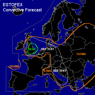

CONVECTIVE FORECAST
VALID Thu 14 Jul 10:00 - Fri 15 Jul 06:00 2005 (UTC)
ISSUED: 14 Jul 09:57 (UTC)
FORECASTER: GATZEN
There is a slight risk of severe thunderstorms forecast across
SYNOPSIS
Well developed subtropical high over Morocco/Algeria ridges northward into western Europe. To the west and east ... upper troughs remain quasi-stationary west of Iberian Peninsula and over southeastern Europe. To the northwest ... intense upper long-wave trough is present over extremely northwestern Europe ... and associated vort-max/short-wave trough travels eastward into Great Britain and western North Sea during the period. At lower levels ... relatively warm airmass dominates the most of Europe south of Scandinavia and northern British Isles ... characterized by steep low-level lapse rates due to strong diurnal heating during the last couple of days. Quite moist and unstable airmass is present in the range of the southeastern trough.
DISCUSSION
...Great Britain and western North Sea...
As strong upper short-wave trough propagates eastward into western British Isles ... a jet streak intensifies over central British Isles at the northern flank of western European subtropical ridge. Latest soundings indicate 500 hPa winds up to 20 m/s over central British Isles ... and it is expected that a well-developed jet streak will form and travels eastward over central England during the afternoon. Latest GFS model run suggests more than 25 m/s at the 500 hPa level. In the range of the right entry region of this jet streak ... models show rather strong DCVA during the afternoon over southern and eastern British Isles and over southern North Sea during the evening/night hours. At lower levels ... an airmass characterized by quite rich low-level moisture is present over northern France and Great Britain ... where surface dewpoint has reached 17°C locally. This plume of warm airmass is expected to spread northeastward east of propagating surface trough over Wales ... and models suggest quite strong QG forcing over England and eastern Scotland during the afternoon hours. As latest satellite image shows mostly clear skies over southern British Isles ... daytime heating should be strong enough for CAPE in the range of several 100 J/kg, although lapse rates should be quite weak over the affected region. Initiation is expected in the early afternoon over central England across Lincolnshire, East Midlands, and northern East Anglia. Thunderstorms that form will likely be well-organized given 20+ m/s deep layer wind shear. Multicells and supercells are expected ... capable of producing large hail, severe wind gusts and tornadoes. As models suggest increasing QG forcing ... thunderstorms may merge into one or two MCS ... and bow echoes are not ruled out ATTM ... posing a threat of severe wind gusts. In the evening ... increasing low-level wind shear is expected as well as decreasing LCL heights ... and chance for tornadoes may increase. Allover threat seems to warrant at least a SLGT. An upgrade to MDT may be warrant in the afternoon hours ... when instability may be larger than expected. Convective activity is expected to spread along the leading edge of warm airmass into North Sea region during the evening/night and may reach southern Scandinavia in the early morning hours. Severe threat should gradually weaken over the North Sea.
...southern Scandinavia, northern and eastern Germany, Czech Rep., Austria, western Balkans, Adriatic...
At the northern and eastern flank of the upper ridge ... increasing deep layer wind shear is expected. At the 500 hPa-level ... a jet streak should develop from northern Germany to eastern Alpine region. At the 300 hPa level ... another jet streak is forecast from eastern Alpine region to southern Italy. At lower levels ... ascends show steep low-level lapse rates over eastern Central Europe, northern and western Balkans, and Adriatic ... where CAPE should reach several hundred J/kg today. Rather weak capping inversion is forecast ... and thunderstorms should form initially over mountains and along low-level boundaries. Best chance for thunderstorms seem to exist over Czech Rep., parts of Austria, and Balkans, while initiation is really questionable over northern/eastern Germany, Denmark, and Adriatic. Given 15+ m/s deep layer wind shear ... thunderstorms may become well-organized ... capable of producing large hail and severe wind gusts. Although LCL heights and low-level wind shear do not look favorable for tornadoes ... one or two events are not ruled out given quite complex orography over the affected region. In the evening ... convective activity should weaken due to weak QG/mesoscale forcing in the range of the upper ridge.
#