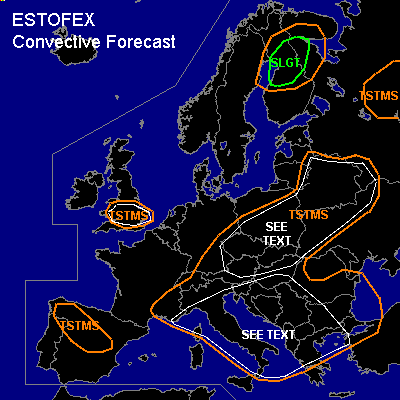

CONVECTIVE FORECAST
VALID Wed 13 Jul 06:00 - Thu 14 Jul 06:00 2005 (UTC)
ISSUED: 13 Jul 00:34 (UTC)
FORECASTER: VAN DER VELDE
There is a slight risk of severe thunderstorms forecast across northern Finland
SYNOPSIS
Yesterday's weather pattern with a surface ridge of high pressure from the British Isles into southern Scandinavia does not chance much, except that the pressure is decreasing and a ENE flow in eastern Europe will turn to a N flow. The upper cold pool is fairly stationary above the Balkan. Weak caps over much of Europe allow deep convection to develop in the early afternoon. Most synoptical-dynamically active weather will be found in northern Finland, where a cold front passes with good shear conditions and some instability.
DISCUSSION
...Northern Finland...
As a continuation of the TSTMS Tuesday evening over Sweden, expect again TSTMS along/ahead of the cold front today. GFS 12Z indicates a few hundred J/kg MLCAPE and a sharp frontal boundary, with 0-1 km average mixing ratios reaching over 10 g/kg. Kinematically, most vertical shear will be behind the cold front, but storms at the front should be able to profit from 15-25 m/s deep layer shear and 8-12 m/s low level shear. Linear forcing may well organise a squall line with damaging gusts... the background wind field is not that strong, but the LCL heights over 2000m suggest an environment of enhanced negative downdraft buoyancy which favors gusts. Though the shear conditions may support supercells, SREH from GFS seems to be enhanced at the cold front itself but disappears at 18Z... so it seems somewhat unclear. Expect gusts as a primary threat, also some isolated large hail and an isolated tornado could occur.
...northern Mediterranean Sea, Adriatic Sea, Ionian Sea, Italy and Balkan...
Like Tuesday, conditions still seem favourable for spout-type tornadoes and funnels in broadly the same area under the upper low. Sea water is anomalously warm for the time of year, which may lead to enhanced lower lapse rates and latent instability. Weak flow and shear conditions could allow for spin-up of vertical vorticity from narrow convergence areas, e.g. the nocturnal land breeze front.
The same may occur over land areas. Storms may move slowly and then cause local flash floods.
...Poland, Belarus and surrounding areas...
Storms are expected to move slowly and may locally cause flash floods. In addition, landspout-type tornadoes may develop under the present weak shear conditions and strong LL lapse rates and 0-3 km CAPE. See the Bologoe Tue 12Z sounding for an extreme example of the airmass advected into Belarus (if reliable)
...southern UK...
Storms are expected to move slowly and may locally cause flash floods.
#