CONVECTIVE FORECAST
VALID Tue 12 Jul 06:00 - Wed 13 Jul 06:00 2005 (UTC)
ISSUED: 12 Jul 08:16 (UTC)
FORECASTER: VAN DER VELDE
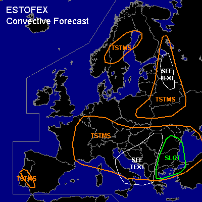
There is a slight risk of severe thunderstorms forecast across Eastern Romania, Bulgaria, eastern Greece, northwestern Turkey
SYNOPSIS
An axis of MSL high pressure stretches from the Atlantic Ocean into the British isles to southern Scandinavia. Low pressure (<1015 hPa) areas are present over the southeastern Balkan and southwestern Spain. In the upper air, a cold pool still dominates most of central and southeastern Europe. Over western Europe, lack of sufficient low-level convergence and upper ascent will likely suppress convective activity although LI are negative. An upper jet reaches over the southeastern Balkan and generates with present latent instability the most active weather.
DISCUSSION
...Eastern Romania, Bulgaria, eastern Greece, northwestern Turkey...
The upper jet region and 500 hPa vorticity generate lift to enhance convective activity in this region, and deep layer shear is in the 15-25 m/s range. Vertical cross-sections of the 00Z GFS model at 12/18Z show a coexistence of latent instability (LI around -2/-3K) together with winds veering from easterly directions at the surface to southerly directions around 500 hPa. This also generates some enhanced SREH values to over 100 m2/s2. Low-level shear will be weak to moderate.
Well-organised storms are expected, including multicell/MCS (+bow-echo) type and some supercell storms, which bear a threat of flash floods, some large hail and likely also an isolated tornado.
...western Balkan and western Russia areas...
Enhanced chance of spout-type tornadoes will be present in these areas due to steep low-level lapse rates and high buoyancy in the 0-3 km layer. Ample vertical vorticity is present in the western Balkan inside the upper low, which will be augmented by local flow features and can be stretched in updrafts. In western Russia, GFS expects a convergence feature which should be the main focus for vertical vortex stretching. Outside of these focus areas, more isolated spouts should still be possible.
#