CONVECTIVE FORECAST
VALID Sat 09 Jul 06:00 - Sun 10 Jul 06:00 2005 (UTC)
ISSUED: 08 Jul 18:19 (UTC)
FORECASTER: TUSCHY
SYNOPSIS
Not much changed compared to yesterday.Main feature of interest will be a major upper level cut-off low,shifting southward over central France during the forecast period. Strengthening WLA downstream of strong depression east of Iceland will help to reinforce ridging over northern Europe although warming in the mid levels will be not enough to suppress scattered TSTM development over Sweden.
DISCUSSION
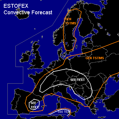
...Western,central and eastern Europe...
Core of cut-off low will move southward from north-central to souteastern France. Colder mid- and uper level airmass should spread southward and will steepen the mid level lapse rates somewhat and forecast soundings also show pretty steep low level lapse rates...all this combined, we will see slightly unstable airmass with low end instability values in the order of 100 - 200 J/kg....Expect scattered TSTM development with a marginal hail threat. Modified low level windfield under the base of this low should locally enhance the possibility for a few funnels or short-lived tornadoes.
Further east over parts of Germany, models don't agree very well with convective precipitation and shear distribution....Current thinking is that southward moving low and accompanying warming in the mid and upper levels should suppress TSTM initiation over northern Germany....Central and southern Germany will see again isolated to scattered TSTM development with main threat being isolated marginal hail and a few funnels.
Widespread TSTM development is expected in the regions southwest of the Carpathian Mountains...Left exit region of very strong upper level jet over the south central Mediterranean area will enhance lift over this area and pretty steep low level lapse rates in the forecast soundings should yield instability in the order of 200 - 300J/kg...Despite somewhat weaker deep layer shear, compared to yesterday,expect some storms producing severe wind gusts and marginal hail....Again,there will be the potential for torrential rain with each storm, moving in a high PWAT axis, extending from eastern Jugoslawia towards eastern Hungary.
...Spain...
Like yesterday, upslope flow could help for isolated TSTM development over the mountians of central and eastern Spain, although compared to yesterday, models develop less convective precipitation signals over this region. Deep layer shear in the order of 40kt would pose a risk for organized storms with main threat being severe wind gusts and large hail...region may need an upgrade if more storms will develop than models forecast.
...South of Sardinia...
GFS shows short wave moving eastward over the south central Mediterranean area. Accompanying lift should be enough for isolated to scattered TSTM development in an environment with 200 - 400 J/kg instability...Deep layer shear in the range of 60 - 80kt should pose a risk for sever wind gusts - especially if bowing lines of storms can develop. Possible entrainment of dry continental airmass from north Africa preclude me for issuing a SLGT risk at the moment.
#