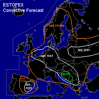
CONVECTIVE FORECAST
VALID Fri 08 Jul 06:00 - Sat 09 Jul 06:00 2005 (UTC)
ISSUED: 07 Jul 18:47 (UTC)
FORECASTER: TUSCHY
There is a slight risk of severe thunderstorms forecast across Yugoslavia,Bosnia-Herzegovina and parts of Croatia
SYNOPSIS
Major upper level cut-off low over central Europe will stay nearly stationary during the forecast period and will be the main focus for convective activity. Northeast Europe will also see broad area of lower geopotential heights where some destabilisation and therefore convective activity will be possible.
DISCUSSION
...Yugoslavia,Bosnia-Herzegovina and parts of Croatia...
Strong mid - and upper level jet developed south of the cut-off low over the central Mediterranean area and will shift eastward towards the risk area. Steep low level lapse
rates will result in widespread release of instability in the order of 200 - 400J/kg....furthermore, the forecast
soundings show only a weakly capped environment and the area expects increasingly lift by left exit region of impressive jet... scattered to widespread convective development is expected in the risk area with main threat being severe wind gusts and isolated large hail.Later in the period, weakening wind field and clustering of the storms could produce very intense rainfall.
Further to the north, over eastern Slovenia and southeast Austria, greater uncertainness exists if enough destabilisation can be realized....Models show enhanced low level shear over south east Austria next to stationary occluded front and there could be an enhanced risk for isolated tornadoes and strong wind gusts...an expansion of the SLGT risk area further northward would be necessary if enough insolation can occur.
...Central Europe...
Broad area with slightly unstable airmass expected under the cut-off low...Most parts of Germany should see isolated TSTM development in a calm kinematic environment....Nevertheless,low LCLs and modified low level wind field ( by topography ) could pose a risk for isolated cold air funnels and marginal hail.
Models also show a short wave rotating around the upper level low towards SE Great Britain, the Netherlands, Belgium and central France....Don't expect too much convective activity,because the wave is forecasted to cross those regions during the night hours -especially over France -...Deep layer shear in the order of 25 to 30kt should be enough for some organized storms with isolated severe wind gusts but allover threat seems to be too marginal for issuing a SLGT risk.
...Eastern Europe...
Expect cold front, which moved down from northeast Europe, become stationary, retreating as a warm front, later in the forecast period . Steep low- and mid level lapse rates north of this front should be enough for the release of some instability [ in the order of 200J/kg ]. Lift along the front and weakly capped environment should produce scattered TSTM acitivity especially over parts of Poland,Ukraina and White-Russia...Low LCLs,deep layer shear in the order of 20kt and maybe enhanced low level shear along the front would pose a risk for an isolated tornado and severe wind gust.
...Spain...
Like yesterday, upslope flow along the mountians should be enough for isolated to scattered TSTM development...Deep layer shear over extreme northeast and eastern Spain will be in the order of 40 to 50kt and each storm will pose a risk for severe wind gusts and isolated large hail...Not issuing a SLGT risk, because no widespread TSTM development is anticipated by the models and they even show slightly higher geopotential heights compared to yesterday, but if a line of storms can develop main risk will be a wind threat and an upgrade would be necessary.
#