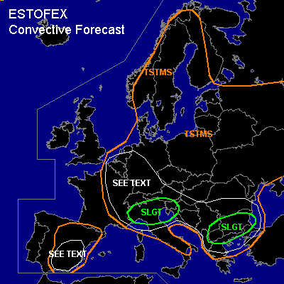

CONVECTIVE FORECAST
VALID Thu 07 Jul 11:00 - Fri 08 Jul 06:00 2005 (UTC)
ISSUED: 07 Jul 10:47 (UTC)
FORECASTER: GATZEN
There is a slight risk of severe thunderstorms forecast across northern Italy, northern Adriatic, northern Balkans
There is a slight risk of severe thunderstorms forecast across southern Balkans
SYNOPSIS
Upper high amplifies over northern Europe. At its southern flank ... an upper cut-off low digs southeastward over Germany, and a relatively strong upper jet streak enters northern Mediterranean. To the east ... weak to moderate upper jet is present from central Mediterranean to Black Sea region. At low levels ... cold maritime airmass has entered most of western and central Europe. Warm and instable airmass remains over northern Mediterranean and southern Balkans as well as over northeastern Europe.
DISCUSSION
...Northern Italy
...
Latest soundings indicate steep low-level lapse rates over northern Italy. Although low-level moisture is quite weak ... diurnal insolation and moisture pooling underneath the inversion should lead to some CAPE today. While low-level winds are expected from the east at the northern flank of weak surface low over northern Mediterranean ... upper level wind should increase from the west as upper jet streak spreads southeastward into northern Italy in the afternoon/evening hours. In association with the upper jet streak ... a vort-max enters northern Italy during the evening and should lead to QG forcing. Due to weak capping inversion over most of Italy ... initiation is expected in the afternoon hours ... initially over the Alps and the western parts, where low-level convergence is expected. Thunderstorms that form should be well-organized given 20+ m/s deep layer wind shear ... and multicells and supercells are forecast ... capable of producing large hail and severe wind gusts. As low-level wind shear is forecast to be quite low ... chance for tornadoes should be not too high. However ... as models predict easterly surface winds and LCL height may vary strongly in time and space ... a few tornadoes are not ruled out. In the evening ... thunderstorms may merge into mesoscale systems moving into northern Adriatic/northern Balkans ... and severe wind gusts should become the most significant threat. Chance for intense precipitation and flash flooding will increase during the evening hours as well.
...Southern Balkans
...
Latest Brindisi sounding shows very rich low-level moisture and relatively steep lapse rates above the boundary layer ... yielding to CAPE of 1500 J/kg. On Thursday ... this airmass is expected to remain over Italy, Adriatic, and southern Balkans ... where latest GFS model run suggests CAPE in the order of 700 J/kg. While capping inversion is expected to inhibit deep convection over Adriatic ... an upper trough that propagates eastward over the Balkans should lead to some QG forcing. At the surface ... associated cold front is forecast to remain over southern Balkans ... where low-level convergence has supported initiation during the last hour. Thunderstorms that form may be severe given 15+ m/s deep layer wind shear. Isolated large hail and severe wind gusts are expected.
...Spain...
Sounding show weak instability over Spain ... and CAPE is expected during the day due to insolation. Although cap is quite strong ... a few thunderstorms may form over the mountains due to upslope flow. Thunderstorms that form may evolve into supercells given 15+ m/s deep layer wind shear. Isolated large hail and severe wind gusts are not ruled out. Overall threat seems to be quite low, though.
...Central Europe
...
In the range of the cut-off low ... showers and thunderstorms have formed. Latest soundings show steep low-level lapse rates and quite rich low-level moisture, yielding low-level CAPE ... and chance for weak tornadoes and waterspouts should be enhanced.
#