CONVECTIVE FORECAST
VALID Tue 05 Jul 06:00 - Wed 06 Jul 06:00 2005 (UTC)
ISSUED: 04 Jul 23:39 (UTC)
FORECASTER: VAN DER VELDE
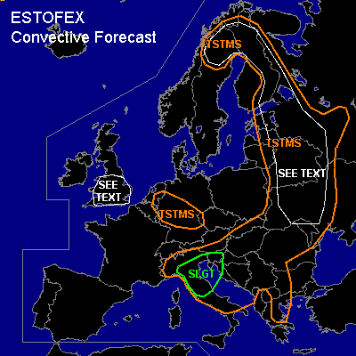
There is a slight risk of severe thunderstorms forecast across Northern Italy, Slovenia and Kroatia
SYNOPSIS
An upper trough filled with cool air resides over the Benelux and surrounding countries. A northwesterly jet at its southern flank stretches out into northern Italy and the Alpine region. The cold front belonging to the low pressure system now over the North Sea slowly moves into Poland, Slovakia, northern Italy and the northern Balkan today. Ahead of the cold front, the airmass is rather dry with LCL heights over 2000 m, BL mixing ratios around 7 g/kg and hence only weak instability.
DISCUSSION
...Northern Italy, Slovenia and Kroatia...
Cold front pushes southeastward into the area from the start of the period and LL convergence ahead is the focus for organised convective development. An elevated nighttime MCS may develop before the forecast period starts and affect the northern part of the area with a primary risk of severe gusts and floodings. As storms become surface-based in the late morning, effectively more shear (up to 20 m/s DL shear) can be used to generate updraft rotation and better storm organisation, with increasing chances of large hail and perhaps a tornado from supercell storms.
The 0-1 km mixed parcel MLCAPE forecast by GFS ranges up to 600 J/kg, however would not be surprised to see around 1000 J/kg MLCAPE if GFS underestimated instability again in this type of situation (cold front over mountain range).
...Ukraine, Belarus, western Russia, eastern Baltic States...
Mon 12Z soundings have shown unstable airmass (200-800 J/kg MLCAPE) in weak flow/vertical shear over large areas in far eastern Europe (Ukraine to Finland). Expect the same conditions today. On a local scale, these storms may produce landspout-type tornadoes, (marginally large) hail, and flash floodings due to slow movement of storms ...if sufficiently moist air will be present... which some Mon 12Z soundings did not show in several locations within the SEE TEXT area.
...Southern UK...
Remaining instability becomes shallower at the advance of warmer air aloft, but GFS shows considerable buoyancy below 700 hPa. In minimal flow conditions, the setup could be favourable to produce a few spout-type tornadoes/funnels, especially where convergence and vorticity organise locally (if LL instability indeed realises)
Other areas where more isolated spout-type tornadoes may form are the TSTMS area over Germany, and southern Sweden.
#