CONVECTIVE FORECAST - UPDATE
VALID Mon 04 Jul 13:00 - Tue 05 Jul 06:00 2005 (UTC)
ISSUED: 04 Jul 13:52 (UTC)
FORECASTER: GROENEMEIJER
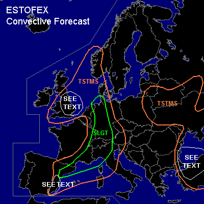
There is a slight risk of severe thunderstorms forecast across much of western, central and southern Germany, the extreme northeastern Netherlands, most of Switzerland, northwestern Italy, southeastern France and northwestern Spain.
SYNOPSIS
refer to original convective forecast
DISCUSSION
...Eastern Netherlands, northwestern Germany, Switzerland...
A long zone of linear convective systems from the northeastern Netherlands southward across the Rhine Valley to Switzerland will likely move eastward as it encounters an air-mass that has been destabilised by solar heating. Some small bows may form over northern Germany as has been the case over the northeastern Netherlands enhancing downbursts. Rather marginal instability ahead of the system...500 J/kg 50-hPa-MLCAPE is was generally observed by 12Z soundings... should limit the coverage of winds exceeding the severe threshold of 25 m/s.
Some bow echoes have formed over southern Germany that are likely causing some severe winds locally as well as some large hail. The intensity of the storms should diminish in a few hours' time as they encounter increasingly drier air further east and the boundary layer temperature starts to drop.
...eastern France, northern Italy...
This area is upgraded to slight as it is recognized that about 1000 J/kg of MLCAPE and 15-20 m/s deep layer shear is present across the area, while forcing for upward motion is expected to affect the area during the afternoon. As a result, widespread convective development is anticipated over the area. Strong multicell clusters and possibly a few supercells will likely be accompanied by a threat of large hail and may additionally produce some strong downbursts. The convection's centre of gravity should shift into Italy after dusk.
...Spain...
refer to the original convective forecast
#