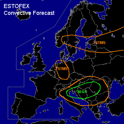

CONVECTIVE FORECAST
VALID Fri 01 Jul 09:00 - Sat 02 Jul 06:00 2005 (UTC)
ISSUED: 01 Jul 09:33 (UTC)
FORECASTER: GATZEN
There is a slight risk of severe thunderstorms forecast across nortern Adriatic and northern Balkans
SYNOPSIS
South of a high over the North Sea and Scandinavia ... rather strong upper jet is present from southern British Isles to northern Mediterranean and northern Black Sea region. A short-wave trough ATTM over eastern France/western Alpine region travels eastward reaching the Balkans during the period. At the surface ... a low is expected to deepen east of the propagating trough ... and moving into western Romania during the period. Warm and unstable airmass is expected to advect into eastern Balkans, while cold airmass spreads into northern Mediterranean in the wake of the trough.
DISCUSSION
...Northern Balkan region
...
Another round of intense convective activity is expected over parts of the Balkans. Latest Udine sounding shows that rich low level moisture and quite steep lapse rates are still present east of developing surface low ... and it is expected that this unstable airmass will advect northeastward into northern Balkans. This airmass should be characterized by weak capping inversion and thunderstorms should likely develop in the range of the surface low and along the cold front moving eastwards into western Balkans. Although models do not show strong deep layer wind shear over the affected region ... it is not ruled out that mid-level jet streaks are embedded in the southwesterly flow at the eastern flank of the trough ... and a few thunderstorms may become severe capable of producing large hail, severe wind gusts and probably a tornado given low LCL heights and complex low-level SRH-field. Allover threat seems to be lower than on Thursday ... however ... a SLGT seems to be warrant ATTM. Most significant threat should be intense precipitation and flash flooding over parts of the Balkans. During the period ... thunderstorms may merge into a MCS moving eastward into Romania ... where intense precip and severe wind gusts should be the main severe threat.
...Central Balkans
...
A MCS has formed over northern Italy that is expected to move ESE-ward into central Balkans during the next hours south of the surface low and east of the propagating trough. Although models do not indicate strong vertical wind shear ... it is not ruled out that embedded mesocyclones will form capable of producing large hail and a tornado or two. Moist significant severe threat should be severe wind gusts as well as flash flooding.
#