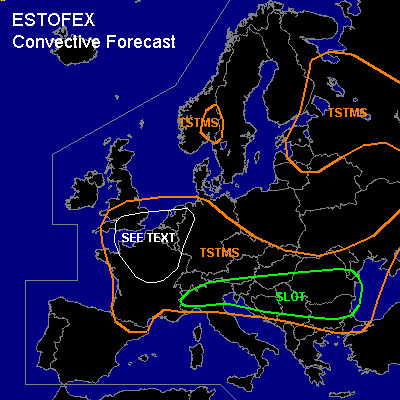

CONVECTIVE FORECAST
VALID Thu 30 Jun 06:00 - Fri 01 Jun 06:00 2005 (UTC)
ISSUED: 29 Jun 21:17 (UTC)
FORECASTER: GATZEN
There is a slight risk of severe thunderstorms forecast across northern Balkans, northern Italy, western Black Sea region
SYNOPSIS
Omega flow pattern has formed over northwestern Europe ... with amplified upper ridge over the North Sea and well-defined long-wave troughs over northern Atlantic and eastern Scandinavia/western Russia. To the south of this omega ... a relatively strong upper jet over northern Atlantic is directed towards western Europe ... Alpine region ... western Russia. Several short waves are embedded within this upper jet. At lower levels ... warm subtropical airmass present over central Europe ATTM is forecast to remain over Mediterranean and the Balkans, while cool maritime airmass spreads into western and central Europe behind a cold front. WAA is expected over Black Sea region.
DISCUSSION
...Balkans, northern Italy, western Black Sea region
...
An upper short-wave trough/vort-max is forecast to travel eastward over the Balkans during the forecast period. Ahead of this feature ... latest model output suggests strong QG forcing to spread over northern and central Balkans into western Black Sea region. At lower levels ... unstable airmass characterized by latest soundings over northern Italy/Alpine region showing steep mid-level lapse rates and rich low level moisture ... yielding CAPE up to more than 2000 J/kg locally ... advects into eastern Balkans ahead of a weak surface low associated with the upper short-wave trough. On Thursday ... current thinking is that an MCS/cluster of nocturnal convective activity will be present over eastern Alpine region/northwestern Balkans. To the southeast ... moderate instability will evolve in the range of the upper trough ... exceeding CAPE of 1000 J/kg locally. Due to rather rich low-level moisture ... cap should be weak over most of the region ... and thunderstorms should form along outflow boundaries and/or orographic features. Deep layer vertical wind shear is expected to increase over northern Balkans in the range of the upper jet ... and multicells/mesocyclones are forecast to form ... capable of producing large hail and severe wind gusts. In the range of the frontal boundary/ as well as outflow boundaries/ low level wind shear is expected to reach more than 10 m/s ... and a few tornadoes are expected ... some of them may be strong. Thunderstorms should merge into some MCS given persistent QG forcing and vertical wind shear ... affecting western Black Sea region at the end of the day. Severe wind gusts may become the most significant threat ... tornadoes and large hail are not ruled out, though. To the west ... QG forcing is expected to be weak in the wake of the upper short-wave trough. However ... unstable airmass is expected to remain over northern Italy and southeastern Alpine region ... and thunderstorms are expected to form along outflow boundaries/orographic features during the day. Deep layer vertical wind shear is expected to be enhanced underneath the upper jet ... and a few thunderstorms should become supercells or multicells ... capable of producing large hail, severe wind gusts ... and probably a tornado ... especially in the range of outflow boundaries. Overall threat seems to be lower than over the Balkans ... a SLGT seems to be necessary ATTM though.
...Southern England, northern France, Benelux, western Germany
...
Another short-wave trough is expected to travel eastwards into France ... western Germany during the period. Affected airmass is expected to be quite unstable as indicated by latest GFS model run ... and should be characterized by rather rich low level moisture and weak cap ... allowing for showers and thunderstorms during the day ... spreading eastward. Although vertical windshear is forecast to be relatively weak ... low LCL heights and at least 7 m/s low level wind shear may enhance the chance for a few shallow mesocyclones ... capable of producing a few (brief) tornadoes. Overall threat is expected to remain low.
#