CONVECTIVE FORECAST - UPDATE
VALID Tue 28 Jun 17:00 - Wed 29 Jun 06:00 2005 (UTC)
ISSUED: 28 Jun 16:49 (UTC)
FORECASTER: GROENEMEIJER
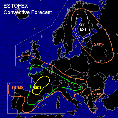
There is a moderate risk of severe thunderstorms forecast across southwestern and central France
There is a slight risk of severe thunderstorms forecast across across an area surrounding the moderate risk area much of France, the southern UK, southern Belgium, Luxembourg, southwestern Germany, Switzerland, western and southern Austria, northern Italy, much of Slovenia, Croatia
SYNOPSIS
refer to convective forecast
DISCUSSION
...southwestern and central France...
Behind a zone of stratiform precipitation over central France, new convective storms are developing along the shore of southwestern France. These storms develop in an environment of around 30 m/s 0-6 km deep-layer shear and about 3000 J/kg of SBCAPE. As a result, a couple of strong and possibly tornadic supercells will likely for in the next couple of hours before clustering into a MCS. The MCS is expected to race northnortheastward over the MDT risk area and cause damaging winds in places.
...north-central and northwestern France, Belgium, soughern England...
Ongoing convective activity over northern France has some potential of producing very strong winds, large hail and possibly even an isolated tornado as about 1000-2500 J/kg MLCAPE... can be released in those storms. However, weak wind shear will likely limit the degree of organzation of the storms, so that severe weather should have a rather isolated nature.
Storms are expected to spread into southern England and Belgium during the evening and overnight where storms should become elevated in nature and their severe threat should slowly diminish. Heavy rainfall may however occur.
...northeastern France, southwestern Germany...
About 3000 J/kg MLCAPE was observed at Nancy 12z and wind shear profiles there and over southwestern Germany should be favourable for supercell storms. Indeed, ongoing storms have split-storm radar characteristics. The coverage of storms is however expected to remain low as a result of weak upper-level support. Very large hail and damaging downbursts, as well as an isolated tornado should be posisble in the area during the coming hours.
...Croatia, Slovenia, southern Austria, northeastern Italy...
Shear and instability as observed at Zagreb at 12Z look favourable for a couple of supercell storms capabale of producing large hail and damaging winds. Hence, the area has now been included in the slight risk area.
#