CONVECTIVE FORECAST
VALID Tue 28 Jun 06:00 - Wed 29 Jun 06:00 2005 (UTC)
ISSUED: 28 Jun 01:18 (UTC)
FORECASTER: GROENEMEIJER
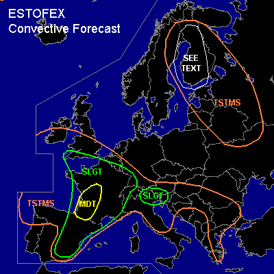
There is a moderate risk of severe thunderstorms forecast across southwestern France
There is a slight risk of severe thunderstorms forecast across an area surrounding the moderate risk area including much of France, extreme southern England, southern Belgium, Luxembourg, southwestern Germany, northern and western Switzerland, much of eastern and northern Spain.
There is a slight risk of severe thunderstorms forecast across the eastern Po-Valley, the southeastern Alps and western Slovenia
SYNOPSIS
Tuesday at 06 UTC... an impressive elevated mixed layer covers the areasouth of a near-stationary front that is expected over the Channel region, the Belgian-French border, southern Germany, Austria and Hungary. A shortwave trough over western Iberia is expected to reach southwestern France at the end of the period. To the northeast...a large low pressure area over western Finland is expected to move southeastward and reach eastern Estonia at the end of the period.
DISCUSSION
...northern and eastern Spain, southwestern and western central France...
With 12-13 g/kg of water vapor in the lowest 500 metres and 18-20 C surface dew points expected by late afternoon, about 1500 J/kg 500m-MLCAPE should be able to form over southwestern France, while slightly lower values are expected across Spain. Storms will likely form during the afternoon over Spain and towards evening over southwestern France ahead of the aformentioned trough. Given that in 25- 35 m/s 0-6 km shear is expected, supercells should be the main convective mode with storms that can remain isolated for some time. Ahead of the trough, cyclogenesis in the lee of the Pyrenees is expected to strenghten leading to increasing low-level shear and low-level helicity over southwestern France, increasing the chance of tornadoes and isolated supercell development in that region.
Overall, rather quick evolution into bowing convecive systems is expected over northern Spain and southwestern France. The bows will likely have a northnortheastward trajectory and continue well into the evening and likely after midnight. While large hail, damaging winds and isolated (possibly strong) tornadoes are expected with isolated supercells, the main threat of the clustered storm systems will be producing damaging winds.
...southern UK, northern France, Belgium, Luxembourg, southwestern Germany
...
As forcing for upward motion increases, the high amounts of instability that have formed near and south ot the warm front are expected to be released on a large scale than on Monday. About 2000 J/kg of MLCAPE are expected to be in place again over parts of northern France. A zone of more than 1000 J/kg of elevated (MU)CAPE is expected to extend westward over the southern UK and the English Channel and northward over the southern Benelux and parts of central Germany. The timing of storms is hard to forecast, but models agree on developing extensive convective coverage near the warm front during the afternoon. Despite deep-layer shear being weak to moderate, the forecast amount of instability suggests that isolated large hail and strong winds may occur. The strong winds are most likely with storms that are surface-based and develop south of the warm front. Additionally, flooding is likely to become a problem in places as small Corfidi-vectors suggest storms will be slow moving.
...eastern Po-Valley, southeastern Alps, western Slovenia...
Although large-scale forcing is expected to be marginal over the region,
isolated storms that manage to develop could be quite severe given that 15-20 m/s 0-6 km shear and in the range of 1000-2000 J/kg of 500m-MLCAPE should be available to any storm. Large hail and strong downbursts are to be expected with those storms. Additionally, lee cyclogenesis may create favourable low-level shear for updraft rotation, so that a few storms may become supercells that have a small risk of producing tornadoes.
...Finland, northern Sweden, Baltic Sea, Gulf of Finland...
Steep low-level lapse rates are expected under the aforementioned low-pressure area. Abundant cyclonic vertical vorticity being present, convective storms that develop along convergence lines may produce weak waterspouts and landspouts.
#