CONVECTIVE FORECAST
VALID Mon 27 Jun 06:00 - Tue 28 Jun 06:00 2005 (UTC)
ISSUED: 26 Jun 23:42 (UTC)
FORECASTER: GROENEMEIJER
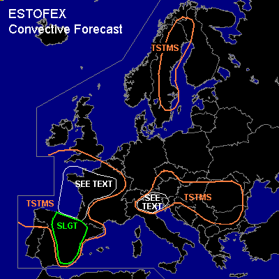
There is a slight risk of severe thunderstorms forecast across parts of central, northern and eastern Spain
SYNOPSIS
Monday at 06 UTC... a mid/upper closed low is expected just west of northern Portugal. A cold front is expected to extend southward from a closed surface low over the central Bay of Biscay to southern Spain. East of this front and south of a warm front over northern France a very warm air-mass is present. A cold front over eastern Europe extends over the southern Ukraine, northern Romania, Hungary and into Austria and is expected to move southward during the forecast period.
DISCUSSION
...Spain...
Numerical models including NMM (2612) and GFS (2612/18) predict seveal weak vorticity maxima to translate northward over eastern Spain. As a result periods of forcing for upward motion will probably affect eastern Spain as well.
Despite the fact that GFS does not develop too much convection, present thinking is that strong insolation should be able to create a few 100's of J/kg of weakly-capped MLCAPE, that will be released in a couple of storms forming during the second half of the afternoon over the slight risk area.
Strong...around or above 20 m/s... deep-layer shear will likely allow some storms to become supercells with a main threat of causing severe winds and large hail. Clustering storms may form small northeastward-moving bows that provide an additional wind threat.
...France...
Near and south of the warm front, kinematic and thermodynamic parameters appear to be favourable for severe storms including tornadic supercells. However, it seems that storms will likely have a low coverage -- if they form at all. A well defined area of negative vorticity is advected over the area nearby the warm front at the time of peak heating and as a result, only very isolated storms are forecast at this moment. If storms become well-organised, they may turn into slowly right-moving supercells providing a threat of large hail, strong winds, flooding and tornadoes. At this moment, not enough confidence is there to warrant issuing a risk category.
Storm coverage will likely increase over the Bay of Biscay and southwestern France overnight as an impulse of forcing for rising motion should affect the area. Most convective activity should be elevated and have a low severe threat.
...Northern Italy and western Slovenia...
About 1000 J/kg MLCAPE is forecast over much of the Po-Valley and the southern Alpine flanks. This, in combination with weak capping and the passage of a cold front from the north will likely induce thunderstorm development. The anticipated moderate deep-layer shear values suggest that strong large-hail producing multicells may form with a smaller additional threat of severe gusts.
#