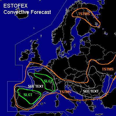

CONVECTIVE FORECAST
VALID Thu 23 Jun 06:00 - Fri 24 Jun 06:00 2005 (UTC)
ISSUED: 22 Jun 18:33 (UTC)
FORECASTER: GATZEN
There is a slight risk of severe thunderstorms forecast across parts of northwestern to central and further to southeastern France
There is a slight risk of severe thunderstorms forecast across northern and northeastern Spain
SYNOPSIS
High over western Mediterranean that ridges into central Europe slowly propagates eastward. To the east of this feature ... an upper short-wave trough moves southeastward over eastern Europe reaching western Black Sea on Friday morning. Associated upper vort-max is expected over north-central Balkans on Thursday ... where QG forcing is forecast by latest GFS model output. Over western Europe/northeastern Atlantic ... upper long-wave trough slowly moves eastward, and two short-wave troughs are expected to travel northeastward over Iberian Peninsula, and France. At lower levels ... quite stable airmass has entered central and eastern Europe in the range of the upper short-wave trough, while instable airmass will be present over France, and Iberian Peninsula.
DISCUSSION
...Iberian Peninsula, France
...
Elevated mixed layer is present from Iberian Peninsula to central France and western Alpine region that should be advected northwestward into northern France during the next hours ahead of propagating short-wave trough ATTM over Bay of Biscay. At lower levels ... rich low-level moisture is present over western Alpine region and southern France ... and latest model output suggests that low-level moisture will continue to increase over central and northern parts of France. To the south ... low-level moisture should be significantly lower over Iberian Peninsula ... where low-level mixing/inverted-v profiles are expected during the day. On Thursday ... two upper short-wave troughs travel northeastward over northwestern France ... and northwestern Iberian Peninsula ... providing weak QG forcing and height falls over the affected region. At the surface ... weak thermally induced low-pressure systems are expected over western Iberian Peninsula, and western France ... and low-level convergence is forecast over central and northern France, and northern Iberian Peninsula. Given steep lapse rates and relatively weak CIN over northern Iberian Peninsula ... thunderstorms should form ... initially where orography/outflow boundaries are favorable for initiation. Thunderstorms that form may become organized given up to 20 m/s deep layer vertical wind shear in the range of the short-wave trough. Large hail should be possible with any supercell that forms. However ... most significant threat should be downbursts due to well-mixed boundary layer/relatively high cloud base ... and severe wind gusts should be possible with any thunderstorms that forms. Allover threat should warrant a SLGT. Convection may merge into one or two MCS/cluster later on as QG forcing/vertical wind shear should remain during the evening/night hours. To the north ... quite similar setup is expected over northern/central France. While deep layer vertical wind shear is forecast to be weaker, low-level moisture should be significantly greater ... and CAPE up to more than 2000 J/kg forecast by latest GFS model run are expected to realize. Thunderstorms that form will likely cluster given weak (below 15 m/s) deep layer vertical wind shear ... and multicells and mesocyclones are not expected to be likely ATTM. However ... in the range of low-level convergence lines/outflow boundaries ... enhanced low-level SRH and moisture may be favorable for an isolated mesocyclone or two ... capable of producing (very) large hail, severe wind gusts and a tornado or two. Most significant threat should be severe wind gusts and local flash flooding due to slow moving storms. Convective activity is expected to cluster and should weaken after sunset.
...Balkans, western Black Sea region
...
Upper short-wave trough propagates southeastward over eastern Europe. At the surface .. a cold front moves southward reaching from northern Adriatic Sea to central Balkans and further to northwestern Sea region on Thursday, 12 UTC. To the south of this front ... latest ascends show quite steep low level lapse rates and inverted-v profiles. On Thursday ... daytime heating should lead to well-mixed and rather dry low-level airmass. Latest GFS model run suggests CAPE in the order of several hundred J/kg. Thunderstorms are expected to form during the day along and south of the cold front as CIN should be quite weak. As deep layer vertical wind shear is expected to increase as the upper trough approaches ... thunderstorms are expected to organize into multicells and mesocyclones ... capable of producing isolated large hail and severe wind gusts. A tornado is not ruled out given quite strong (10+ m/s) low-level vertical wind shear along the surface cold front and indicated by latest GFS model run. However ... QG forcing will be limited over most of the affected region ... and given quite weak thermodynamic profiles ... severe thunderstorms should be isolated/short-lived. Strongest forcing is expected over western Black Sea region, where QG forcing/low level convergence is expected ... and thunderstorms may merge into an MCS later on. Overall threat is expected to be marginally SLGT ... and an upgrade to SLGT may be warrant on Thursday.
#