CONVECTIVE FORECAST
VALID Wed 22 Jun 06:00 - Thu 23 Jun 06:00 2005 (UTC)
ISSUED: 22 Jun 00:39 (UTC)
FORECASTER: GROENEMEIJER
SYNOPSIS
Wednesday at 06... a broad ridge is present over much of western Europe. A cold front initially from the Baltic Sea to the central Alps is expected to mvoe southeastward during the day.
DISCUSSION
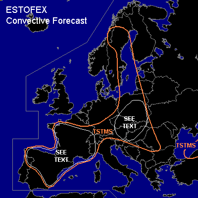
...France...
A capped latently unstable air-mass is present over central and southern France. It is expected that in respnse to insolation around 1000 J/kg of MLCAPE will build over much of the area and that the cap will weaken. As a result isolated convective storms are expected to form over the area. Given the significant instability, the presence of mid-level dry layers and a deep, dry boundary layer, there is a potential for isolated severe downbursts with the storms. Additionally, some large hail may occur locally. The expected isolated nature of storms and severe weather preclude the issuance of a risk category.
...Spain...
In a deep, dry boundary layer on the order of 500 J/kg MLCAPE is expected to form. weak capping will probably allow for isolated to scattered storms to form that may produce strong downdrafts, that may be severe locally. Some localized hail is possible as well.
...Poland, Czech republic, Slovakia, Hungary, Austria...
Ahead of the aformentioned cold front, storms will likely form and/or intensify during the day. Although CAPE is quite limited with a few 100's of J/kg MLCAPE forecast, rather strong shear in the lowest 3km may allow for a few organized severe storms to form. Linearly organized storms and possibly a few mesocyclones are possible. These may yield a threat of strong winds, some hail, and perhaps an isolated tornado. The overall threat should however, given the forecast meager instability, be rather small, so that a risk category is not issued at the moment.
#