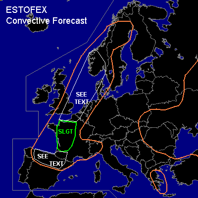

CONVECTIVE FORECAST
VALID Mon 20 Jun 06:00 - Tue 21 Jun 06:00 2005 (UTC)
ISSUED: 19 Jun 23:37 (UTC)
FORECASTER: GROENEMEIJER
There is a slight risk of severe thunderstorms forecast across western France
SYNOPSIS
East of a diffuse frontal zone from western Norway over northern England towards northwestern Spain, a deep, elevated mixed layer (EML) is present. A warm air-mass resides over central Europe, where the flow is weak, while a low-pressure area present at both upper, mid and lower tropospheric levels is centered over the area south of Moscow.
DISCUSSION
...Western France...
Quite respectable amounts of moisture are present below the EML over western France and southeastern England, where 0-1 km mixing ratios of about 10-12 g/kg were observed on Sunday at 12Z. As the frontal zone is expected to shift eastward before and during the forecast period, it is expected that surface-based instability will be confined to continental Europe. Numerical models suggest that in response to abundant solar heating, a respectable amount of 1000 J/kg 500m-MLCAPE and probably in excess of 2000 J/kg SBCAPE will form over parts of western France. Current thinking is that GFS predicts the extent of convective initiation better tomorrow than NMM, that postpones initiation until well after midnight. GFS has analyzed a vorticity maximum, that should be located around 400 km north of Galicia by Monday 06Z and move northeastward.
The most likely sceario seems that in response to insolation and weak rising motions ahead of the vorticity maximum, the convective inhibition will practically disappear by mid- or late afternoon over the slight risk area and scattered convective storms will initiate. Vertical wind shear is expected to be low... on the order of 5-10 m/s in the 0-6 km layer... but a threat of severe weather is nevertheless anticipated: the steep lapse rates around and above the freezing level suggest a large hail threat with any storm that becomes multicellular, while the presence of dry mid-levels and a deeply mixed boundary layer suggests a risk of locally severe downbursts. After sunset, the storms will likely become elevated, while their severe weather threat gradually diminishes.
...northern Spain...
Scattered storms are expected to form over Spain as well. Lower instability is expected over the area limiting the severe threat. Nevertheless a couple of strong or severe downbursts may occur, given the forecast inverted-V profiles.
...southern Norway, North Sea...
Elevated convection is expected to be ongoing over the central North Sea and parts of southern Norway Monday morning by 06Z. Some, mostly small, hail and gusty winds seem likely with this activity, that should diminish by early afternoon.
...England, Benelux countries, western Denmark...
As the aformentioned vorticity maximum travels northeastward, weak rising motions are expected to overspread northwestern France, the southeastern UK and the Benelux countries overnight. In response, the development of elevated storms is possible. These may bring some large hail and possibly strong winds as well. The overall threat however is rather low.
#