CONVECTIVE FORECAST
VALID Fri 17 Jun 06:00 - Sat 18 Jun 06:00 2005 (UTC)
ISSUED: 16 Jun 18:00 (UTC)
FORECASTER: TUSCHY
There is a slight risk of severe thunderstorms forecast across South east Norway and southern Sweden
SYNOPSIS
European weather will be dominated by a deep trough west of Ireland during the next 24 hours. Downstream of this system, very warm air will be advected northeastward and will help a ridge to strengthen over central Europe. East and south east Europe will see the effects of a broad, but weak upper level trough....widespread destabilisation during the afternoon hours should occur with this feature. Area of heigt falls will cross north east Europe and will be the focus for a developing depression over White Russia in the latter half of the outlook time frame.
DISCUSSION
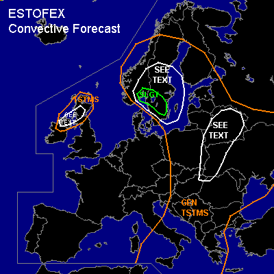
...South east Norway and southern Sweden...
Very intense mid and upper level jet will cross the region during the forecast period from north west to south east. Ageostrophic circulation associated with left exit region of this jet should cause a broad area of lift over parts of Norway and Sweden during the afternoon hours...Marginal deep layer shear won't favor an organisation threat of TSTMs,so main risk will be strong to isolated severe wind gusts and a marginal hail threat because of slightly cooler mid and upper level temperatures....Main concern will be a small area over southern Sweden. Past model runs showed a southward shift of instability and convective signals in each run. Current thinking is that isolated to scattered storms will develop in the SLGT risk area....Impressive deep layer shear in the order of 35m/s will be enough for each storm posing a threat of severe wind gusts, especially if small lines of TSTMs can develop.
...Scotland and northern Ireland...
Warm front will cross Scotland between 6 and 12 UTC....Postfrontal, strong warming in mid and upper levels should help to inhibit TSTM initiation over the area of interest till the early afternoon hours...Developing capping inversion and marginal insolation are expected and forecasted instability of models - about 200 to 300 J/kg - looks reasonable....During the early evening hours, an occluded front should arrive from the west, but orientation of front nearly parallel to streamlines won't favor too much southward shift....Current thinking is that isolated to scattered TSTMs will develop in an environment with weak deep layer shear, but enhanced low level shear in the order of about 12m/s....12Z (16th June) sounding LCL reports over southern Great Britain ( from where airmass will be advected) and forecasted model LCLs are pretty low and one or two tornadoes can't be ruled out....but main threat will be strong to isolated severe wind gusts.
...White Russia,western Ukraina and eastern Poland...
Upper diffluent flow and extending strong jet in the SEE TEXT area will create a favorable environment for widespread TSTM development....Instability values in the range of 800 to 1100J/kg will be more than enough to sustain those TSTMs...There will be the threat for torrential rain, because of an humid airmass and weak shear ( slow storm propagation)and also isolated strong wind gusts.
#