CONVECTIVE FORECAST
VALID Tue 14 Jun 06:00 - Wed 15 Jun 06:00 2005 (UTC)
ISSUED: 14 Jun 01:29 (UTC)
FORECASTER: VAN DER VELDE
SYNOPSIS
An old, barotropic low pressure area is centered on the North Sea. A (upper) trough will move at its east flank over Norway. The cold front occlusion associated with the low stretches from the Baltic States into Germany and France and remains fairly stationary. On its east side, TSTMS can feed on warm and moist air. A slight wave in the front travels from France into Germany/Poland in the afternoon. Southern France and Italy will deal with a weak ENE-moving upper trough that is associated with a mix of elevated and SFC based convection. A frontal zone remains stationary over Finland and Russia.
DISCUSSION
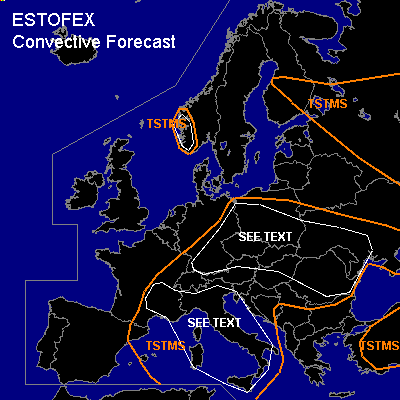
...SE France, Italy, Mediterranean...
Overnight MCSses travel eastward into the region by Tue morning. Most convection should be elevated or have high LFCs... this and the organization poses mainly some threat for severe gusts... but overall there is no sharp focus for convection and low level wind fields are not expected to be too significant... DL shear can amount up to 35 kts and can yield some well-organised storms...possibly also with large hail. As moist air flows upslope Alps, storms may drop large amounts of rain, potentially causing local floodings.
...Germany, Poland, Czech Republic, Slovakia, northern Balkan...
As waving front travels northeastward, expect enough lift and moderate shear to be present and generate an MCS in western parts of the area. Since kinematic fields are not particularly impressive, thinking is that storms will generally be sub-severe... possibly some large hail. SREH will be enhanced across eastern Germany according to NMM and GFS 12Z, and some storms may develop rotating updrafts which will enhance hail threat. Hail will also be the main type of severe weather across the rest of the region as well, as e.g. Slovakia 12Z sounding of previous day showed steep low-midlevel lapse rates and several hundred J/kg MLCAPE. However, shear that was present in soundings here yesterday will now be weaker due to decreasing height gradients in the upper air.
...western Norway...
NMM and GFS both agree on some marginal instability at the passage of trough from the south. There should be ample lift and low-level shear in the order of > 10 m/s, with NMM SR-helicity values show 150-250 m2/s2, also to be augmented by local orography. Despite shallow convective layer, may see some briefly rotating updrafts and hence a large hail/tornado threat, but overall confidence is low because of the very marginal instability.
#