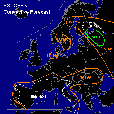

CONVECTIVE FORECAST - UPDATE
VALID Sun 12 Jun 15:00 - Mon 13 Jun 06:00 2005 (UTC)
ISSUED: 12 Jun 15:46 (UTC)
FORECASTER: GATZEN
There is a slight risk of severe thunderstorms forecast across northwestern Russia
SYNOPSIS
Extended upper trough centered over southern Scandinavia and the North Sea. Vort-maxima traveling around the main trough are present over southern Baltic region, southern central Scandinavia, and northern central British Isles. Over extremely southeastern Europe ... old cut-off low moves northward at the eastern flank of European trough ... leading to strong DCVA over western parts of Russia. Over southern Europe ... southern branch of upper jet streak remains east of a cut-off low placed near northwestern Iberian Peninsula ... and several weak vort-maxima travel eastward into Mediterranean. At lower levels ... cold polar airmass is present north of a frontal boundary reaching from northern Spain to central France to Alpine region. Cold airmass is also present over the Balkans and eastern Mediterranean in the wake of mentioned cut-off low over southeastern Europe. On Sunday ... relatively strong upper vort-max moves southward over British Isles ... leading to westerly to southwesterly upper winds over southern Central Europe ... while frontal boundary over France/Alpine region propagates northward.
DISCUSSION
...Northwestern Russia...
This update is based on latest soundings over northwestern Russia ... where significant CAPE has formed just east of a frontal boundary that is quasistationary from southern Finland to St. Petersburg and further southward over western Russia. To the south ... strong upper short-wave trough/vort-max moves northward ... providing QG forcing along this boundary. At low levels ... a surface low pressure system has formed over western Russia along the frontal boundary that is expected to move northwards during the next hours. In the range of this low pressure system ... latest soundings show rich low-level moisture ... reaching mixing ratio of 12 g/kg in the lowest 100 hPa locally (St. Petersburg). Weak CIN is present ... and thunderstorms have already formed. Deep layer vertical wind shear is relatively weak east of the frontal boundary. However ... latest models show that vertical wind shear should be rather strong in the range of the frontal boundary ... with deep (0-6 km) vertical wind shear around 20 m/s and low-level (0-1 km) vertical wind shear around 12 m/s. Given low LCL heights, rather strong low-level wind shear, quite steep low-level lapse rates and weak CIN ... chance for tornadoes is expected to be enhanced with any supercell that forms. During the next hours ... quite strong WAA is present along the frontal boundary over northwestern Russia ... southern Finland ... and thunderstorms that have formed may organize into one or two MCS given moderate to strong deep layer wind shear and persistent QG forcing. This convective activity is expected to spread NNE-ward along the frontal boundary ... reaching southern Finland during the night hours ... where convection is expected to be elevated due to rather cold airmass over extremely southern Finland. However ... it is not ruled out that strong wind gusts will occur over a rather broad area in the range of the frontal boundary ... exceeding severe limits locally. To the east of this MCS ... forcing should be weaker ... but isolated to scattered thunderstorms are forecast due to weak CIN. As vertical wind shear will be quite strong in the range of the frontal boundary ... thunderstorms may be severe capable of producing isolated large hail, severe wind gusts and a few tornadoes.
#