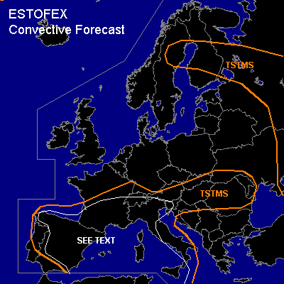

CONVECTIVE FORECAST
VALID Sun 12 Jun 12:00 - Mon 13 Jun 06:00 2005 (UTC)
ISSUED: 12 Jun 12:22 (UTC)
FORECASTER: GATZEN
SYNOPSIS
Extended upper trough centered over southern Scandinavia and the North Sea. Vort-maxima traveling around the main trough are present over southern Baltic region, southern central Scandinavia, and northern central British Isles. Over extremely southeastern Europe ... old cut-off low moves northward at the eastern flank of European trough ... leading to strong DCVA over western parts of Russia. Over southern Europe ... southern branch of upper jet streak remains east of a cut-off low placed near northwestern Iberian Peninsula ... and several weak vort-maxima travel eastward into Mediterranean. At lower levels ... cold polar airmass is present north of a frontal boundary reaching from northern Spain to central France to Alpine region. Cold airmass is also present over the Balkans and eastern Mediterranean in the wake of mentioned cut-off low over southeastern Europe. On Sunday ... relatively strong upper vort-max moves southward over British Isles ... leading to westerly to southwesterly upper winds over southern Central Europe ... while frontal boundary over France/Alpine region propagates northward.
DISCUSSION
...Southern France to Alpine region
...
In the range of the frontal boundary ... relatively moist low level airmass is present from France to northern Balkans. Aloft ... steep lapse rates originating from Iberian Peninsula spreads northeastward. Latest soundings show CAPE in the order of several hundred J/kg. Today ... insolation is expected from southern France to western Alpine region ... where latest satellite image show mostly clear skies. Initiation is expected along and south of the frontal boundary during the next hours. Due to quite weak vertical wind shear ... severe thunderstorms seem to be unlikely. However ... along the frontal boundary ... locally enhanced low-level wind shear and relatively large CAPE values may be possible ... and one or two thunderstorms may be severe capable of producing large hail and severe wind gusts.
...Iberian Peninsula
...
Over Iberian Peninsula ... some DCVA is expected east of the upper cut-off low. Latest soundings show very steep lapse rates and CAPE over central and eastern Iberian Peninsula. Due to insolation ... CAPE should likely reach several 100 J/kg ... and initiation is expected along old outflow boundaries and orographic features ... where low-level convergence and/or moisture should be most favorable. Thunderstorms that form will have a potential of severe wind gusts given well-mixed boundary layer below the cloud base. Over eastern Iberian Peninsula ... deep layer vertical wind shear may reach more than 20 m/s during the afternoon/evening hours in the range of upper jet streak ... and potential for isolated mesocyclones capable of producing severe wind gusts and large hail should increase. Allover threat is too low for a SLGT.
...Western Mediterranean
...
Over western Mediterranean ... quite strong vertical wind shear is forecast underneath the southern jet stream ... reaching more than 25 m/s locally. Several weak vort-maxima are expected to travel eastward ... and QG forcing is expected as WAA is present east of the cut-off low over Iberian Peninsula. Latest model output suggest CAPE during the afternoon/evening hours. Current thinking is that initiation will be likely over Islands due to orographic lift/differential heating. Thunderstorms that form may develop mesocyclones capable of producing large hail and severe wind gusts. However ... is is not expected that long-lived thunderstorms will form, as QG forcing remains quite low. Expect one or two severe events during the period ... and a SLGT seems to be not warrant ATTM.
#