CONVECTIVE FORECAST
VALID Fri 10 Jun 06:00 - Sat 11 Jun 06:00 2005 (UTC)
ISSUED: 09 Jun 19:53 (UTC)
FORECASTER: TUSCHY
SYNOPSIS
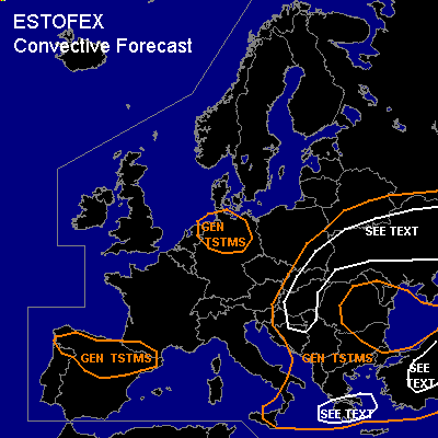
Highly amplified weather pattern continues during the forecast period.Between an unusually strong but weakening high pressure between Great Britain and Iceland and an elongated, negatively tilted trough, very cool airmasses flooded most parts of central Europe.This trough will be the main focus for TSTM initiation over southeast Europe.Weak cold front will arrive in North Germany during the day and could be a focus for isolated TSTM development...like Spain, where a short wave trough should produce isolated TSTMs.
DISCUSSION
...Ukraina,eastern Poland,Slovakia and Hungary...
Southern part of double-barrel through continues its slowly northeastward shift during the day and will enter the area of interest in the late afternoon hours....Strengthening frontogenesis will continue from the beginning over Ukraina and current thinking is that this will produce numerous showers and TSTMs which will quickly cluster...Furthermore not much widespread organisation expected because of bad collocation of shear and instability axis....Later in the period, arriving mid-level jet streak -left exit region-,diffluent upper level flow,arriving short wave and ongoing frontogenesis should enhance the development for widespread showers and TSTMs with torrential rainfall and isolated strong wind gusts being the main threat...
Rest of SEE TEXT area will also see strong frontogenesis processes with near neutral forecast soundings....Don't want to exclude isolated to scattered TSTMs with forecasted low CAPE values....Humid airmass,low LCLs and very strong low level shear in the range of 15m/s will pose a locally enhanced threat for an isolated tornado but TSTM distribution should be too marginal for warranting a SLGT.
...Southeast Italy,Greece and Turkey...
Trough axis will move eastward from southern Italy towards Greece in the next 24 hours. Accompanying cooler mid and upper level airmass should destabilisize the atmosphere in a corridor between south east Italy and south Greece...Current thinking is that Greece will see enhanced lift during the early afternoon hours, through arriving trough axis and left exit region of strong jet....Although not much instability was shown by models, up to 30m/s deep layer shear would be more than adequate for TSTMs, producing strong to severe wind gusts...If a line of TSTMs can develop, more widespread severe wind gusts can be expected but last model runs didn't show that much lift over the Ionic Sea, so holding of a SLGT ATM....Further east over Turkey, models develop some instability, but current sounding reports show very dry boundary layer with NMM forecast sounding of Afyon predicting "inverted-V type" soundings....Increasing lift with approaching trough axis should help to produce isolated to scattered TSTMs...Deep layer shear up to 20m/s and low to moderate instability should be enough for isolated large hail, although strong to severe wind gusts will be the main threat, regarding the downburst potential.
#