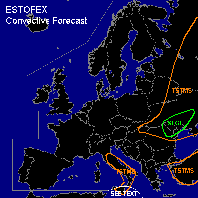

CONVECTIVE FORECAST
VALID Thu 09 Jun 06:00 - Fri 10 Jun 06:00 2005 (UTC)
ISSUED: 08 Jun 19:00 (UTC)
FORECASTER: GATZEN
There is a slight risk of severe thunderstorms forecast across
SYNOPSIS
Unseasonable strong high present over western Europe dominates European upper flow regime ... with quite intense outbreaks of arctic airmass into central Europe ... leading to cut-off low pressure systems over the Balkans and central Mediterranean. A strong cut-off low is forecast to dig northeastward over northern Balkans on Thursday. At lower levels ... warm airmass is present east of the cut-off low over Black Sea region, while most of Europe and central Mediterranean has been flooded by cold airmass. Over Iberian Peninsula ... warm airmass is present in the range of western European ridge axis.
DISCUSSION
...Southern Ukraine, Moldova, northeastern Romania
...
Quite strong jet streak curves around the upper cut-off low centered over northern Balkans ... affecting southern Balkans and western Black Sea region in Thursday. At lower levels ... warm and unstable airmass is present over Turkey, Black Sea, and Ukraine. A warm front is expected to move northwestward east of deepening surface low pressure system over Romania ... while a cold front is forecast to remain over eastern Romania. In the warm sector ... GFS shows the development of CAPE during the day. Soundings are not available to confirm this forecast. On Thursday ... some insolation is expected in the warm sector and CAPE should be possible given actual dewpoints in the mid 10s and likely quite steep lapse rates in the mid-troposphere. During the day ... QG forcing is expected due to DCVA at the cyclonic flank of the upper jet streak. Thunderstorms are expected to initiate along old outflow boundaries and the cold front. Relatively strong vertical wind shear ... with southerly winds at the surface and SSWerly winds up to 30 m/s at the 300 hPa level ... should be sufficient for a few severe thunderstorms ... capable of producing severe wind gusts and large hail. Best chances for tornadoes exist along the surface warm front over Moldova region ... where low-level winds should be easterly and low-level wind shear in expected to increase during the day. Thunderstorms should merge into one or two cluster/MCS along the cold front during the evening/night.
...Southern central Mediterranean
...
Upper trough axis/vort max of Mediterranean low is expected to travel eastward over southern central Mediterranean. Affected airmass is forecast to be unstable by latest GFS model run. However ... although no sounding information is available ... there exists great uncertainty about this forecast ... given quite cool water surface and rather dry low-level airmass. Thunderstorms that form will likely organize as deep layer wind shear is expected to reach more than 25 m/s south of Italy. However ... allover threat seems to be low given uncertainty of initiation and instability ATTM.
#