CONVECTIVE FORECAST
VALID Wed 08 Jun 09:00 - Thu 09 Jun 06:00 2005 (UTC)
ISSUED: 08 Jun 08:25 (UTC)
FORECASTER: GROENEMEIJER
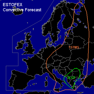
There is a slight risk of severe thunderstorms forecast across parts of Greece, Albania, the F.Y.R. of Macedonia, southern Serbia and Montenegro, western Bulgaria and southwestern Romania
SYNOPSIS
At mid- levels a low pressure area is expected to cut-off from an elongated trough with its axis from the Baltic Sea to the Adriatic. A jet streak on the southern flank of the cut-off low over the northwestern Balkans is expected over southern Italy and moves into Albania Macedonia and northern greece during the forecast period.
DISCUSSION
...SLGT risk area...
Forcing for upward vertical motion in the left exit region of the aformentioned jet-streak will likely cause extensive convective developmenet over the SLGT risk area, where up to 1000 J/kg of SBCAPE should be able to build.
Deep-layer shear of around 50 m2/s2 and helical profiles in the jet's exit region suggest that some storms, although rapidly clustering, could develop rotating updrafts. Hence, large hail and strong to severe gusts are to be expected. One or two tornadoes are not ruled out either although low-level shear should generally not be particularly strong, as it may be locally enhanced by interaction with hills and mountains.
#