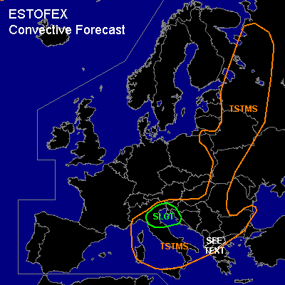

CONVECTIVE FORECAST
VALID Tue 07 Jun 06:00 - Wed 08 Jun 06:00 2005 (UTC)
ISSUED: 07 Jun 00:19 (UTC)
FORECASTER: VAN DER VELDE
There is a slight risk of severe thunderstorms forecast across northern Italy, Slovenia, Istria, western Kroatia
SYNOPSIS
High pressure has built up near the UK and Benelux while weak low pressure resides over (south)eastern Europe. Cool air is advected by northerly winds over much of Europe along the east side of the high. A high amplitude upper long-wave trough sinks southward over central Europe into the Balkan. The southward jetstream at 300 hPa reaches 100 kts over Germany. Strong lift will be present over the cold front at the southeast side of the Alps due to DCVA and divergence in the left exit region of the jet.
A thermal low will grow over southern Iberian Peninsula with steep lapse rates, however strong capping is likely to prevent moist convection.
DISCUSSION
...northern Italy, Slovenia, Istria, western Kroatia...
As discussed above, strong lifting mechanism plunges into the area. Low-level convergence is expected ahead of the cool airmass that rapidly advances southward around the eastern Alps. Before the cold front passage, some instability (few hundred J/kg MLCAPE forecast by NMM, GFS and BOLAM) should be able to build up. There will also be deep layer shear around of 15-25 m/s... however, the increase in wind speeds with height is not everywhere in the area significant over the lowest 3 km as idicated by GFS and MM5. At 18Z, GFS and NMM generate some 0-3 km SREH and enhanced LL shear (>10 m/s) mostly over the eastern part of the SLGT, but it seems that will be in the cool air, without instability.
Thinking is that a few thunderstorms may form during the afternoon, that have the potential to organise into strong multicells or supercells, posing a risk of large hail and gusts (midlevel dry air). Tornado chances should be limited as LL shear is not particularly large. A MCS may develop, however... doubt that pool of moisture will be large enough to sustain one for a significantly long time.
...northern Greece, Albania...
Small area of marginal instability and convective precip as in GFS and NMM will be accompanied by strong (>25 m/s) deep-layer shear. On a very local scale, storms are likely to develop that may profit from shear and produce large hail, but given marginal CAPE they may just as well be sheared apart.
#