CONVECTIVE FORECAST - UPDATE
VALID Sun 05 Jun 12:00 - Mon 06 Jun 06:00 2005 (UTC)
ISSUED: 05 Jun 14:04 (UTC)
FORECASTER: VAN DER VELDE/LANKAMP
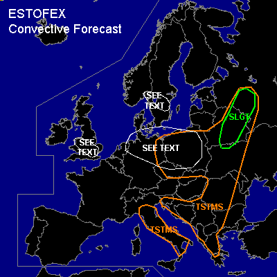
There is a slight risk of severe thunderstorms forecast across Belarus, extreme western Russia
SYNOPSIS
An old cold front associated with a SFC low over Sweden/Finland stretches from Finland southward into the Balkan. Unstable airmassses are in a zone at at the warm side of the cold front, and in the maritime polar airmass under the broad upper trough over north-central Europe.
DISCUSSION
...SLGT area over Belarus/Russia...
A line of storms has formed in an airmass that should have MLCAPE's of 500-1000 J/kg according to GFS and up to 300 J/kg by NMM. The region is under moderate DL shear conditions (around 15 m/s 0-6 km, best shear lagging behind the unstable airmass) and LL shear is moderate to fairly strong. Main severe weather threat is for severe gusts, if a bow echo squall line is able to form. Otherwise, with more isolated cells, rotation may develop and some chance exists for large hail and a tornado, since LFCs are also fairly low at below 1500m.
...central UK...
A small band of unstable air has developed convection. GFS 06Z shows a line of convergence and soundings showed low level CAPE with moist low levels, and midlevels being dryer. Together with benign LL winds, situation seems ideal for a few spout-type tornadoes. However, the depth of instability and hence potential decreases during the afternoon as a ridge settles over the region.
...part of Sweden, northern central Europe...
00-12Z soundings in the region have shown considerable deep low level moisture/RH humidities and fairly steep lapse rates... a few hundred J/kg uncapped CAPE is available and has produced numerous storms... LL shear is weak to moderate, including veering winds with height over Germany that may indicate sufficient SREH for updraft rotation and perhaps a tornado... furthermore, spin-up of vorticity i.e. spout-type tornadoes are favored especially if a line of convergence is present. However, there is currently no such line clearly present, except over Sweden, where also 13Z sfc obs show convergence. Additionally to spouts, Legionowo 12Z sounding showed more than 400 J/kg CAPE and moderate shear and is good for some large hail.
#