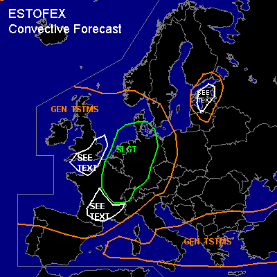
CONVECTIVE FORECAST
VALID Fri 03 Jun 06:00 - Sat 04 Jun 06:00 2005 (UTC)
ISSUED: 02 Jun 21:44 (UTC)
FORECASTER: TUSCHY
There is a slight risk of severe thunderstorms forecast across Eastern France, NW Switzerland,most parts of Germany, central Danemark,Netherlands and Belgium
SYNOPSIS
During the next 24 hours, strong trough, now situated west of Ireland, will race eastward and should affect most parts of western and north western Europe. Downstream of this system, strengthening WAA will help to intensify ridging over most parts of southern and central Europe. Trough over north east Europe should drift slowly northeastward and should continue its weakening trend.
DISCUSSION
...Eastern France, NW Switzerland,most parts of Germany, central Danemark,Netherlands and Belgium...
Main problem during the forecast period will be the assessment how much humidity will be transported northward towards the SLGT risk area...Theta-e advection regime from southern France northward should develop per GFS and NMM. Dewpoint values of 12-15C are expected to be in place over Germany northern France and the Low countries tomorrow, which together with abundant insolation should result in 500 - 1200 J/kg MLCAPE....We will have a few possibilities for TSTM initiation during the forecast period....Isolated to scattered TSTM will possibly develop during the early noon hours along eastward moving cold front over northern and central France....Deep layer shear of 20m/s, but pretty unidirectional flow will favor the chance for a line of TSTMs,possibly with embedded bow echoes...Main threat should be strong to severe wind gusts and isolated large hail, but also one or two tornadoes can't be ruled out - although development along cold front
and weak low level shear won't favor any higher tornado threat -....During the afternoon hours, cell development along the mountains of south east France should occur and current thinking is that this activity will develop during the same time,when convergence along the French-German border should initiate prefrontal TSTMs....Strongest forcing and shear will be found in the northern SLGT area, where the possibility for a strong MCS with embedded bow echoes and supercells will be given....if adequate humidity can advect towards NW Germany, Netherlands and Belgium, there will be an increased chance for some tornadoes, seeing low LCLs, 12m/s + low level shear, 0-1km SRH values in the order of 100-150**2/s**2 and strong veering wind field...Furthermore, 20m/s deep layer shear will pose a risk for storms with large hail and severe wind gusts, especially if an organized line of storms can develop...this region will be monitored for possibly upgrading.....Further south, strong MCS should develop from south central France all the way towards central Germany...Weaker shear, but better instability should help to initiate widespread cell development over southern France...however, shear will be enough for an embedded bow echo or supercell...Main feature of interest for southeast France and southern Germany will be a jet streak, which was calculated by the models pretty consistent during the past runs...if this verifies,strengthening low level shear and low LCLs could pose a risk for one or two tornadoes, although main threat will be strong to severe wind gusts.... Later in the period, those MCSs will move east-northeastward, slowly weakening because of decreasing instability.
...English Channel and England...
Early during the forecast period, strong convergence north east of weakening low pressure - situated over north west France -, combined with eastward moving cold front should help for scattered TSTM initiation mainly over the English Channel and England...Unsecurities exist, how strong the release of instability will finally be, but each cell will be in an environment with favorable kinematic parameters, so there will be the possibility for isolated strong to severe wind gusts and an isolated tornado.
...Estland...
Weak short wave and near neutral soundings show the possibility for isolated TSTM initiation in this area. 15m/s deep layer shear would be enough for strong to severe wind gusts in stronger cells, but limited instability and only weak forcing should hinder the development for widespread TSTMs.
#