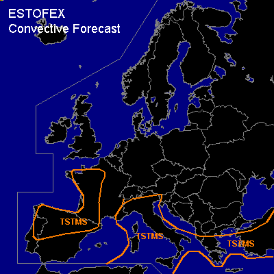

CONVECTIVE FORECAST
VALID Thu 02 Jun 06:00 - Fri 03 Jun 06:00 2005 (UTC)
ISSUED: 01 Jun 21:38 (UTC)
FORECASTER: GATZEN
SYNOPSIS
Low geopotential covers most of northern Atlantic and Scandinavia. To the south ... rather strong upper flow is present from Great Britain to northern Germany, western Black Sea and further to northwestern Russia. Two short-wave troughs embedded in the mean flow travel eastwards over western Europe and eastern Europe, while upper ridge axis is present from western Mediterranean to North Sea region. While quite cool and mostly stable airmass is present over northern Europe ... airmass is well-mixed over the Mediterranean and southeastern Europe.
DISCUSSION
...Southeastern Europe
...
Unstable airmass is present over Turkey ... and another round of convection is expected on Thursday. While rather strong upper jet is forecast to the north of this airmass, severe potential seems to be limited over Turkey. Deep layer wind shear should be below 20 m/s and only isolated marginal severe thunderstorms are forecast.
...Mediterranean...
Low level airmass is quite well-mixed over the land masses of Mediterranean ... and should destabilize due to insolation. Thunderstorms are expected along sea breeze convergences. Deep layer wind shear will be relatively weak ... and severe thunderstorms seem to be not likely.
...Southwestern Europe
...
East of propagating upper trough ... airmass over Iberian Peninsula and France is forecast to destabilize in response to diurnal heating, increasing low-level moisture and upper level cooling. Amount of available moisture is unclear at this time. However ... thunderstorms should develop as QG forcing is likely at the flank of the upper trough. Deep layer wind shear is forecast to increase during the evening ... and severe thunderstorms may form. Later observations and model output have to be awaited for an update.
#