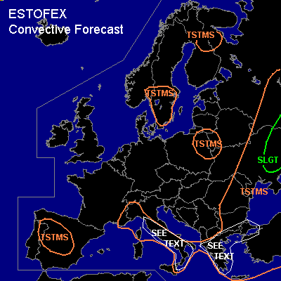

CONVECTIVE FORECAST
VALID Wed 01 Jun 06:00 - Thu 02 Jun 06:00 2005 (UTC)
ISSUED: 01 Jun 01:09 (UTC)
FORECASTER: GROENEMEIJER
There is a slight risk of severe thunderstorms forecast across the eastern Ukraine and adjacent parts of Russia
SYNOPSIS
Wednesday at 06 UTC... a mid/upper-level trough is expected over central Scandinavia. A cold front is expected near a line from Moscow to Sofia, ahead of which an unstable air-mass is present. Both the trough and the front are expected to move slowly eastward. Upstream... an Atlantic low pressure system slowly approaches the British Isles. Over southern Europe, the flow is generally weak. A weak mid and upper level trough is present over the Iberian peninsula and Morocco.
DISCUSSION
...Eastern Ukraine, adject parts of Russia...
Numerous elevated convective storms are expected to be ongoing near the cold front at the beginning of the forecast period. Give that elevated CAPE may be near 1000 J/kg, there is some risk of hail with the storms. As the boundary layer ahead of the front warms during the day, surface-based storms are expected to form. Current thinking is that in the range of 1000-2000 J/kg MLCAPE should become available to the storms while deep-layer shear will be favourable of multicells, and perhaps a few supercells. Main risks of the storms will be strong downbursts and large hail. There is a threat of tornadoes as well in case a baroclinic wave forms, as suggested by GFS, that causes backing surface winds in the warm air. GFS has such a development in store for Wednesday evening over the eastern Ukraine, but looks unrealistically aggressive. An update may be issued should a risk upgrade be necessary for an area within the forecast area. Otherwise, the severe threat should slowly subside overnight.
...parts of Greece, northwestern Turkey and Italy...
NMM and GFS suggest that locally in excess of 1000 J/kg of SBCAPE may form in the labelled areas across which shear should be strong enough for well-organised multicell storms. Hence a risk of large hail and rather strong downbursts will be present wherever storms initiate in those areas.
#