CONVECTIVE FORECAST
VALID Tue 31 May 06:00 - Wed 01 May 06:00 2005 (UTC)
ISSUED: 31 May 01:27 (UTC)
FORECASTER: VAN DER VELDE
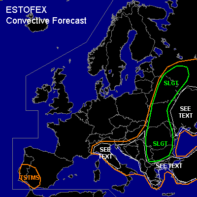
There is a slight risk of severe thunderstorms forecast across Belarus and extreme W-Russia
There is a slight risk of severe thunderstorms forecast across W-Ukraine, Romania, Moldova, Bulgaria and Serbia
SYNOPSIS
A cold front advances into warm, humid airmasses over Eastern Europe, Italy and the Balkan. A negatively tilted upper trough induces a wave in the cold front with enhanced upward motion and deepening surface low, over Belarus and western Russia. Less baroclinic low pressure areas remain over the Balkan, Turkey, Italy and Spain.
DISCUSSION
...SLGT Belarus and extreme W-Russia / eastern SEE TEXT area ...
Linear forcing along the cold front near the wave over Belarus is likely to rapidly generate a squall line in the late morning/early afternoon in the airmass that is expected to have around 1000 J/kg MLCAPE. DL shear conditions are generally 10-20 m/s 0-6 km, which can potentially organise strong multicells and a few supercells besides the expected squall line... with a good chance of producing large hail and locally severe outflow winds. Given that the upper jetstream lags the cold front, ventilation of storm tops seems not ideal, making main storm mode outflow dominant and eventual supercells shortlived, since also SREH is generally meager, except for some NMM and GFS spots of 100-150 m2/s2.
Ukraine, SW Russia: higher LFCs/CINs and less synoptic/mesoscale forcing likely produce only isolated storms, but with chance of large hail and severe downbursts due to dry upper air. The MCS expected in the SLGT will move into this area after 00Z, with still some potential of gusts/hail.
...SLGT W-Ukraine, Romania, Moldova, Bulgaria and Serbia / SEE TEXT Balkan, Turkey...
As cold front moves into the Balkan, moisture convergence focuses into a line ahead of the front. Initially some storms will develop over mountain ranges in the early afternoon, followed by more as the front pushes in, feeding on MLCAPEs in the range of 700-1500 J/kg. Despite only weak-moderate shear conditions, still expect some large-hail- and windstorms, and floodings. Since LFCs will be lower than previous days, expect that on isolated scale some cells may produce a tornado especially if profiting from a little SREH (orographically enhanced). During the evening, a MCS may have formed and enhance the threat for severe gusts.
Turkey, Balkan: as above, but storm coverage should be less due to only weak, local scale forcing.
...SEE TEXT N-Italy...
As the cold front passes over the Alps and Po valley, moisture converges in the area and is probably going to trigger a few storms, that may be well-organised multicells or supercells with DL shear reaching over 15 m/s in the north of the area, and enhanced SREH (>100 m2/s2) in the eastern parts according to GFS and NMM models. Expect some large hail, and severe outflow winds by evaporational cooling of the downdraft, as air aloft is dry.
#